File:Ysgyryd Fawr trig point - geograph.org.uk - 1450779.jpg
Jump to navigation
Jump to search
No higher resolution available.
Ysgyryd_Fawr_trig_point_-_geograph.org.uk_-_1450779.jpg (640 × 350 pixels, file size: 45 KB, MIME type: image/jpeg)
Captions
Captions
Add a one-line explanation of what this file represents
Summary
[edit]
| Description |
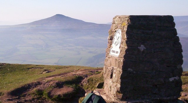
English: Ysgyryd Fawr trig point Ysgyryd Fawr, or Skirrid Fawr (486m). Situated on the outskirts of Abergavenny Gwent. Known locally as 'The Holy Mountain'. There are remains of an ancient chapel on the summit. The western end of the mountain had a substantial landslide at some time. Locally, stories state the land slide occurred at the exact moment Jesus died on the cross. The photo of the National Trust trig point, looking west towards Sugar Loaf Mountain. |
| Date | |
| Source | From geograph.org.uk |
| Author | Stephen MARSDEN |
| Attribution (required by the license) | Stephen MARSDEN / Ysgyryd Fawr trig point / |
| Camera location | | View this and other nearby images on: OpenStreetMap |
|---|
_heading:270.00&language=en)
| Object location | | View this and other nearby images on: OpenStreetMap |
|---|
_heading:270.00&language=en)
Licensing
[edit]

|
This image was taken from the Geograph project collection. See this photograph's page on the Geograph website for the photographer's contact details. The copyright on this image is owned by Stephen MARSDEN and is licensed for reuse under the Creative Commons Attribution-ShareAlike 2.0 license.
|
This file is licensed under the Creative Commons Attribution-Share Alike 2.0 Generic license.
Attribution: Stephen MARSDEN
- You are free:
- to share – to copy, distribute and transmit the work
- to remix – to adapt the work
- Under the following conditions:
- attribution – You must give appropriate credit, provide a link to the license, and indicate if changes were made. You may do so in any reasonable manner, but not in any way that suggests the licensor endorses you or your use.
- share alike – If you remix, transform, or build upon the material, you must distribute your contributions under the same or compatible license as the original.
File history
Click on a date/time to view the file as it appeared at that time.
| Date/Time | Thumbnail | Dimensions | User | Comment | |
|---|---|---|---|---|---|
| current | 06:57, 2 March 2011 | | 640 × 350 (45 KB) | GeographBot (talk | contribs) | == {{int:filedesc}} == {{Information |description={{en|1=Ysgyryd Fawr trig point Ysgyryd Fawr, or Skirrid Fawr (486m). Situated on the outskirts of Abergavenny Gwent. Known locally as 'The Holy Mountain'. There are remains of an ancient chapel on the summ |
You cannot overwrite this file.
File usage on Commons
There are no pages that use this file.