File:Yongin-map.png
Jump to navigation
Jump to search

Size of this preview: 688 × 600 pixels. Other resolutions: 275 × 240 pixels | 551 × 480 pixels | 881 × 768 pixels | 1,174 × 1,024 pixels | 1,500 × 1,308 pixels.
Original file (1,500 × 1,308 pixels, file size: 201 KB, MIME type: image/png)
Captions
Captions
Add a one-line explanation of what this file represents
Summary
[edit]
| Description |
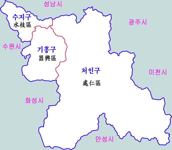
한국어: 용인시 행정구역(구급) English: Administrative map of Yongin city |
| Date | 18 December 2011 (original upload date) |
| Source | Transferred from ko.wikipedia to Commons. |
| Author | Gloyacks at Korean Wikipedia |
Licensing
[edit]
| |
This work has been released into the public domain by its author, Gloyacks, at the English Wikipedia project. This applies worldwide. In case this is not legally possible: |
Original upload log
[edit]
The original description page was here. All following user names refer to ko.wikipedia.
| Date/Time | Dimensions | User | Comment |
|---|---|---|---|
| 2011-12-18 09:11 | 1500×1308× (205445 bytes) | Gloyacks | {{파일 정보 |설명=용인시 행정구역(구급) |출처=자작 |날짜=2011년 12월 18일 |만든이=장길산 |저작권= |기타= }} |
File history
Click on a date/time to view the file as it appeared at that time.
| Date/Time | Thumbnail | Dimensions | User | Comment | |
|---|---|---|---|---|---|
| current | 18:12, 13 February 2016 | | 1,500 × 1,308 (201 KB) | Xia (talk | contribs) | Transferred from ko.wikipedia |
You cannot overwrite this file.
File usage on Commons
There are no pages that use this file.
File usage on other wikis
The following other wikis use this file:
- Usage on hu.wikipedia.org
- Usage on ja.wikipedia.org
- Usage on ko.wikipedia.org