File:Yobe Basin OSM.svg
Jump to navigation
Jump to search

Size of this PNG preview of this SVG file: 567 × 354 pixels. Other resolutions: 320 × 200 pixels | 640 × 400 pixels | 1,024 × 639 pixels | 1,280 × 799 pixels | 2,560 × 1,598 pixels.
Original file (SVG file, nominally 567 × 354 pixels, file size: 2.76 MB)
Captions
Captions
Add a one-line explanation of what this file represents
Summary
[edit]
| Description |
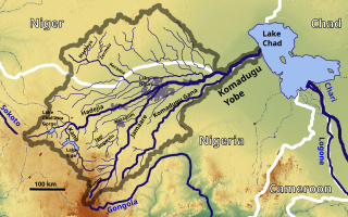
English: The Yobe Basin OSM, Based up on US Army map ND32 - 33 |
| Date | |
| Source | https://maps-for-free.com, http://legacy.lib.utexas.edu/maps/ams/africa_1m/ |
| Author | Hans Braxmeier & Peter in s |
This file is licensed under the Creative Commons Attribution-Share Alike 2.0 Generic license.
- You are free:
- to share – to copy, distribute and transmit the work
- to remix – to adapt the work
- Under the following conditions:
- attribution – You must give appropriate credit, provide a link to the license, and indicate if changes were made. You may do so in any reasonable manner, but not in any way that suggests the licensor endorses you or your use.
- share alike – If you remix, transform, or build upon the material, you must distribute your contributions under the same or compatible license as the original.
File history
Click on a date/time to view the file as it appeared at that time.
| Date/Time | Thumbnail | Dimensions | User | Comment | |
|---|---|---|---|---|---|
| current | 07:14, 9 September 2019 | | 567 × 354 (2.76 MB) | Peter in s (talk | contribs) | {{Information |description ={{en|1=The Yobe Basin OSM}} |date =2019-09-09 |source =https://maps-for-free.com/ |author =Hans Braxmeier & Peter in s }} {{cc-by-sa-2.0}} Category:Maps of rivers of Nigeria Category:Drainage basin maps of Africa Category:Rivers of Niger |
You cannot overwrite this file.
File usage on Commons
The following page uses this file:
File usage on other wikis
The following other wikis use this file:
- Usage on de.wikipedia.org
- Usage on ff.wikipedia.org
- Usage on fr.wikipedia.org
- Usage on ha.wikipedia.org