File:Yeonpyeong shelling locations.png
Jump to navigation
Jump to search
No higher resolution available.
Yeonpyeong_shelling_locations.png (638 × 549 pixels, file size: 69 KB, MIME type: image/png)
Captions
Captions
Add a one-line explanation of what this file represents
Summary
[edit]
| Description |
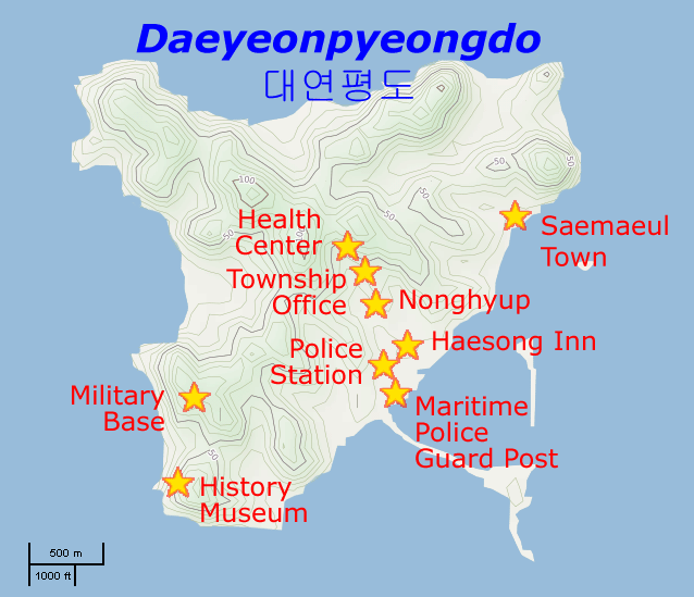
English: Map of the localities hit by the Yeonpyeong shelling of 23 November 2010 |
| Date | |
| Source | Basic map is from OpenStreetMaps (Cycle Map layer); localities data is from [1] |
| Author | Prioryman (talk) |
Licensing
[edit]
| I, the copyright holder of this work, release this work into the public domain. This applies worldwide. In some countries this may not be legally possible; if so: I grant anyone the right to use this work for any purpose, without any conditions, unless such conditions are required by law. |
File history
Click on a date/time to view the file as it appeared at that time.
| Date/Time | Thumbnail | Dimensions | User | Comment | |
|---|---|---|---|---|---|
| current | 22:43, 26 November 2010 | | 638 × 549 (69 KB) | Prioryman (talk | contribs) | == {{int:filedesc}} == {{Information |Description={{en|Map of the localities hit by the Yeonpyeong shelling of 23 November 2010}} |Source=Basic map is from OpenStreetMaps (Cycle Map layer); localities data is from [http://joongangdaily.joins.com/article/v |
You cannot overwrite this file.
File usage on Commons
There are no pages that use this file.
File usage on other wikis
The following other wikis use this file:
- Usage on de.wikipedia.org
- Usage on en.wikipedia.org
- Usage on fr.wikipedia.org
- Usage on it.wikipedia.org
- Usage on ja.wikipedia.org
- Usage on ko.wikipedia.org
- Usage on no.wikipedia.org
- Usage on uk.wikipedia.org