File:Yazoo & Mississippi Valley Railroad - System Index Map.jpg
Jump to navigation
Jump to search

Size of this preview: 409 × 599 pixels. Other resolutions: 164 × 240 pixels | 327 × 480 pixels | 524 × 768 pixels | 699 × 1,024 pixels | 1,397 × 2,048 pixels | 3,177 × 4,656 pixels.
Original file (3,177 × 4,656 pixels, file size: 2.38 MB, MIME type: image/jpeg)
Captions
Captions
Add a one-line explanation of what this file represents
Summary
[edit]| System Index Map
( |
||||||||||||||
|---|---|---|---|---|---|---|---|---|---|---|---|---|---|---|
| Creator | Interstate Commerce Commission. Bureau of Valuation, Engineering Section. 1910? | |||||||||||||
| Title |
System Index Map |
|||||||||||||
| Description |
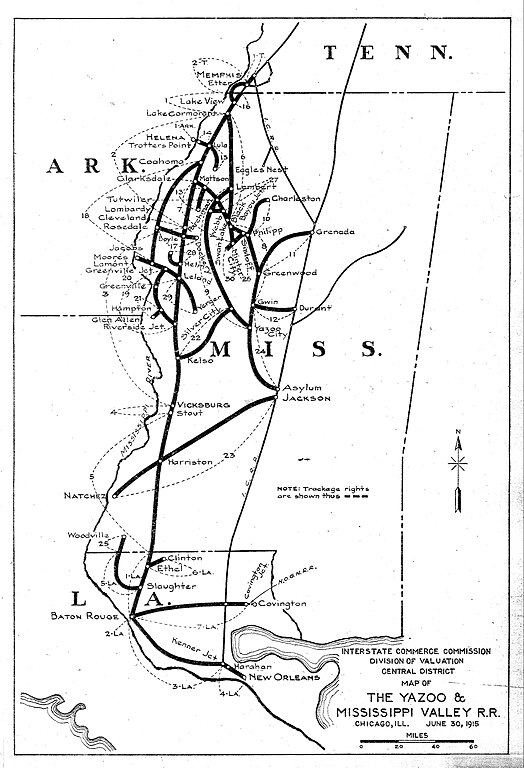
This system index map pertains to the Yazoo & Mississippi Valley Railroad |
|||||||||||||
| Date | 1915-01-01/1920-12-31 | |||||||||||||
| Collection |
|
|||||||||||||
| Source/Photographer |
|
|||||||||||||
| Permission (Reusing this file) |
|
|||||||||||||
| Standardized rights statement |
|
|||||||||||||


File history
Click on a date/time to view the file as it appeared at that time.
| Date/Time | Thumbnail | Dimensions | User | Comment | |
|---|---|---|---|---|---|
| current | 15:15, 28 July 2024 | | 3,177 × 4,656 (2.38 MB) | Jengod (talk | contribs) | Crop, straighten, contrast |
| 16:53, 9 November 2022 |  | 3,296 × 5,100 (2.36 MB) | DPLA bot (talk | contribs) | Uploading DPLA ID eac77fe7d8113ad89ecc952026597a2f |
You cannot overwrite this file.
File usage on Commons
The following 6 pages use this file:
- User:Chumwa/OgreBot/Public transport information/2024 July 21-31
- User:Chumwa/OgreBot/Transport Maps/2024 July 21-31
- User:Chumwa/OgreBot/Travel and communication maps/2024 July 21-31
- User:GeorgR (de)/Rail Transport in the US/2024 July
- File:System Index Map - DPLA - eac77fe7d8113ad89ecc952026597a2f.jpg (file redirect)
- File:Yazoo & Mississippi Valley Railroad - System Index Map.jpg
File usage on other wikis
The following other wikis use this file:
- Usage on en.wikipedia.org