File:Yamanote Shitamachi.gif
Jump to navigation
Jump to search
Size of this preview: 800 × 557 pixels. Other resolutions: 320 × 223 pixels | 640 × 445 pixels | 963 × 670 pixels.
Original file (963 × 670 pixels, file size: 48 KB, MIME type: image/gif)
Captions
Captions
Add a one-line explanation of what this file represents

|
This map image could be re-created using vector graphics as an SVG file. This has several advantages; see Commons:Media for cleanup for more information. If an SVG form of this image is available, please upload it and afterwards replace this template with
{{vector version available|new image name}}.
It is recommended to name the SVG file “Yamanote Shitamachi.svg”—then the template Vector version available (or Vva) does not need the new image name parameter. |
Summary
[edit]
| Description |
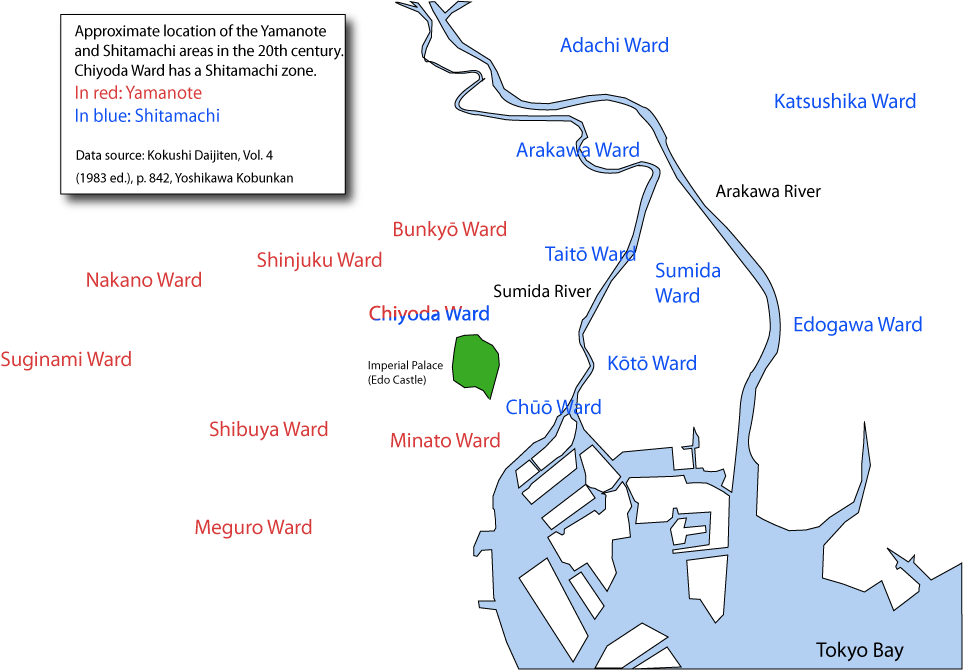
English: A map showing the approximate extension of the Yamanote and Shitamachi areas in Tokyo . Editable svg version also uploaded. |
| Date | |
| Source | Own work |
| Author | Urashimataro |
| Permission (Reusing this file) |
Public Domain |
Licensing
[edit]
| I, the copyright holder of this work, release this work into the public domain. This applies worldwide. In some countries this may not be legally possible; if so: I grant anyone the right to use this work for any purpose, without any conditions, unless such conditions are required by law. |
File history
Click on a date/time to view the file as it appeared at that time.
| Date/Time | Thumbnail | Dimensions | User | Comment | |
|---|---|---|---|---|---|
| current | 04:11, 18 June 2009 | | 963 × 670 (48 KB) | Urashimataro (talk | contribs) | Modified caption |
| 04:05, 18 June 2009 |  | 1,500 × 1,044 (83 KB) | Urashimataro (talk | contribs) | Added some data | |
| 08:47, 17 June 2009 |  | 1,500 × 1,044 (81 KB) | Urashimataro (talk | contribs) | Larger size, added names of rivers and more wards | |
| 05:10, 17 June 2009 |  | 831 × 670 (41 KB) | Urashimataro (talk | contribs) | == Summary == {{Information |Description={{en|1=A map showing the approximate extension of the Yamanote and Shitamachi areas in Tokyo}}. Editable svg version also uploaded. |Source=Own work by uploader |Author=Urashimataro |Date=Jun |
You cannot overwrite this file.
File usage on Commons
There are no pages that use this file.
File usage on other wikis
The following other wikis use this file:
- Usage on bcl.wikipedia.org
- Usage on en.wikipedia.org
- Usage on es.wikipedia.org
- Usage on fa.wikipedia.org
- Usage on fr.wikipedia.org
- Usage on ms.wikipedia.org
- Usage on th.wikipedia.org
- Usage on vi.wikipedia.org