File:Yacimiento aqueológico de Acusa.png
Jump to navigation
Jump to search

Size of this preview: 800 × 560 pixels. Other resolutions: 320 × 224 pixels | 640 × 448 pixels | 1,024 × 717 pixels | 1,280 × 896 pixels | 2,738 × 1,916 pixels.
Original file (2,738 × 1,916 pixels, file size: 10.03 MB, MIME type: image/png)
Captions
Captions
Add a one-line explanation of what this file represents
Summary
[edit]
| Description |
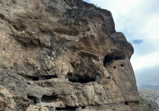
Español: El yacimiento arqueológico de Acusa se distingue como un enclave emplazado en un entorno inaccesible, donde los antiguos habitantes de Gran Canaria resguardaban sus excedentes agrícolas en estructuras conocidas como "silos". Este sitio arqueológico revela la ingeniosa adaptación de las comunidades prehistóricas al medio ambiente insular, destacando la importancia de la conservación y almacenamiento de alimentos en una topografía singular. Los silos, testimonios materiales de prácticas agrícolas y estrategias de subsistencia, ofrecen valiosos insights sobre la vida y la cultura de los habitantes ancestrales de la isla. Acusa emerge así como un fascinante testimonio arqueológico que arroja luz sobre la historia y la vida cotidiana en Gran Canaria.
English: The archaeological site of Acusa is distinguished as an enclave located in an inaccessible environment, where the ancient inhabitants of Gran Canaria kept their agricultural surpluses in structures known as "silos". This archaeological site reveals the ingenious adaptation of prehistoric communities to the island environment, highlighting the importance of food conservation and storage in a unique topography. The silos, material testimonies of agricultural practices and subsistence strategies, offer valuable insights into the life and culture of the island's ancestral inhabitants. Acusa thus emerges as a fascinating archaeological testimony that sheds light on the history and daily life in Gran Canaria.
Deutsch: Die archäologische Stätte von Acusa zeichnet sich durch eine Enklave in einer unzugänglichen Umgebung aus, in der die alten Bewohner Gran Canarias ihre landwirtschaftlichen Überschüsse in sogenannten „Silos“ lagerten. Diese archäologische Stätte offenbart die geniale Anpassung prähistorischer Gemeinschaften an die Inselumgebung und unterstreicht die Bedeutung der Lebensmittelkonservierung und -lagerung in einer einzigartigen Topographie. Die Silos, materielle Zeugnisse landwirtschaftlicher Praktiken und Subsistenzstrategien, bieten wertvolle Einblicke in das Leben und die Kultur der Ureinwohner der Insel. Acusa erweist sich somit als faszinierendes archäologisches Zeugnis, das Licht auf die Geschichte und das tägliche Leben auf Gran Canaria wirft. |
| Date | |
| Source | Own work |
| Author | Pomatomidae |
| Camera location | | View this and other nearby images on: OpenStreetMap |
|---|
Licensing
[edit]
I, the copyright holder of this work, hereby publish it under the following license:
This file is licensed under the Creative Commons Attribution 4.0 International license.
- You are free:
- to share – to copy, distribute and transmit the work
- to remix – to adapt the work
- Under the following conditions:
- attribution – You must give appropriate credit, provide a link to the license, and indicate if changes were made. You may do so in any reasonable manner, but not in any way that suggests the licensor endorses you or your use.
File history
Click on a date/time to view the file as it appeared at that time.
| Date/Time | Thumbnail | Dimensions | User | Comment | |
|---|---|---|---|---|---|
| current | 11:48, 28 December 2023 | | 2,738 × 1,916 (10.03 MB) | Pomatomidae (talk | contribs) | Uploaded own work with UploadWizard |
You cannot overwrite this file.
File usage on Commons
There are no pages that use this file.