File:Y Gaer Fawr, Carn Goch - geograph.org.uk - 301473.jpg
Jump to navigation
Jump to search
No higher resolution available.
Y_Gaer_Fawr,_Carn_Goch_-_geograph.org.uk_-_301473.jpg (418 × 278 pixels, file size: 24 KB, MIME type: image/jpeg)
Captions
Captions
Add a one-line explanation of what this file represents
Summary
[edit]
| Description |
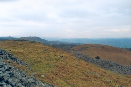
English: Y Gaer Fawr, Carn Goch Carn Goch's 2nd hillfort, a longer site, with many hutcircles inside, and some very large lines of stone ramparts, but not as well preserved as Y Gaer Fach.
Both are well positioned above the Tywi valley, a few miles upstream from Llandeilo. |
| Date | |
| Source | From geograph.org.uk |
| Author | Matthew Hatton |
| Attribution (required by the license) | Matthew Hatton / Y Gaer Fawr, Carn Goch / |
| Object location | | View this and other nearby images on: OpenStreetMap |
|---|
_heading:270.00&language=en)
Licensing
[edit]

|
This image was taken from the Geograph project collection. See this photograph's page on the Geograph website for the photographer's contact details. The copyright on this image is owned by Matthew Hatton and is licensed for reuse under the Creative Commons Attribution-ShareAlike 2.0 license.
|
This file is licensed under the Creative Commons Attribution-Share Alike 2.0 Generic license.
Attribution: Matthew Hatton
- You are free:
- to share – to copy, distribute and transmit the work
- to remix – to adapt the work
- Under the following conditions:
- attribution – You must give appropriate credit, provide a link to the license, and indicate if changes were made. You may do so in any reasonable manner, but not in any way that suggests the licensor endorses you or your use.
- share alike – If you remix, transform, or build upon the material, you must distribute your contributions under the same or compatible license as the original.
File history
Click on a date/time to view the file as it appeared at that time.
| Date/Time | Thumbnail | Dimensions | User | Comment | |
|---|---|---|---|---|---|
| current | 23:01, 22 December 2010 | | 418 × 278 (24 KB) | GeographBot (talk | contribs) | == {{int:filedesc}} == {{Information |description={{en|1=Y Gaer Fawr, Carn Goch Carn Goch's 2nd hillfort, a longer site, with many hutcircles inside, and some very large lines of stone ramparts, but not as well preserved as Y Gaer Fach. Both are well p |
You cannot overwrite this file.
File usage on Commons
There are no pages that use this file.
File usage on other wikis
The following other wikis use this file:
- Usage on de.wikipedia.org