File:Wyndham Place and St Mary's Church - geograph.org.uk - 542453.jpg
Jump to navigation
Jump to search
No higher resolution available.
Wyndham_Place_and_St_Mary's_Church_-_geograph.org.uk_-_542453.jpg (640 × 480 pixels, file size: 74 KB, MIME type: image/jpeg)
Captions
Captions
Add a one-line explanation of what this file represents
Summary
[edit]
| Description |
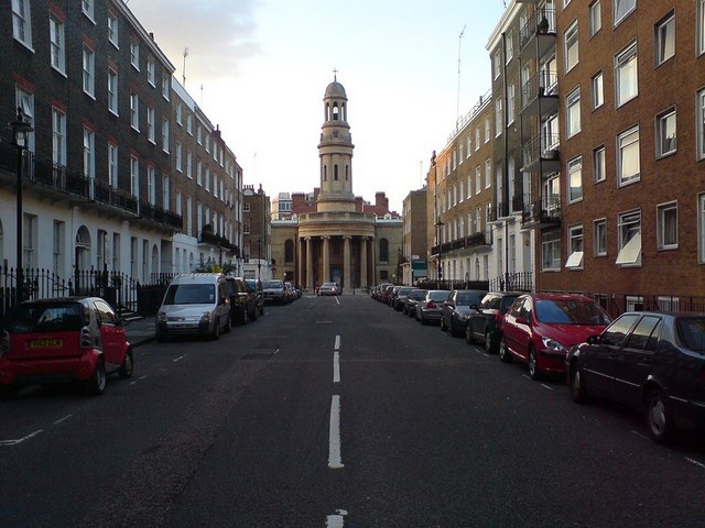
English: Wyndham Place and St Mary's Church. Compare with the picture from 1960 325347. Not much has changed about the buildings - the modern building on the right has filled the gap that was there in 1960. Another change isn't visible - I was standing on the traffic island that has been added at the end of the street, about where the white line ends in the old picture. |
| Date | |
| Source | From geograph.org.uk |
| Author | RichTea |
| Camera location | | View this and other nearby images on: OpenStreetMap |
|---|
_heading:0.00&language=en)
| Object location | | View this and other nearby images on: OpenStreetMap |
|---|
_heading:0.00&language=en)
Licensing
[edit]

|
This image was taken from the Geograph project collection. See this photograph's page on the Geograph website for the photographer's contact details. The copyright on this image is owned by RichTea and is licensed for reuse under the Creative Commons Attribution-ShareAlike 2.0 license.
|
This file is licensed under the Creative Commons Attribution-Share Alike 2.0 Generic license.
Attribution: RichTea
- You are free:
- to share – to copy, distribute and transmit the work
- to remix – to adapt the work
- Under the following conditions:
- attribution – You must give appropriate credit, provide a link to the license, and indicate if changes were made. You may do so in any reasonable manner, but not in any way that suggests the licensor endorses you or your use.
- share alike – If you remix, transform, or build upon the material, you must distribute your contributions under the same or compatible license as the original.
File history
Click on a date/time to view the file as it appeared at that time.
| Date/Time | Thumbnail | Dimensions | User | Comment | |
|---|---|---|---|---|---|
| current | 01:20, 6 February 2011 | | 640 × 480 (74 KB) | GeographBot (talk | contribs) | == {{int:filedesc}} == {{Information |description={{en|1=Wyndham Place and St Mary's Church Compare with the picture from 1960 [325347]. Not much has changed about the buildings - the modern building on the right has filled the gap that was there in 1 |
You cannot overwrite this file.
File usage on Commons
The following page uses this file:
File usage on other wikis
The following other wikis use this file:
- Usage on en.wikipedia.org
- Usage on www.wikidata.org