File:Wv New Island banner.jpg
From Wikimedia Commons, the free media repository
Jump to navigation
Jump to search
![File:Wv New Island banner.jpg](https://upload.wikimedia.org/wikipedia/commons/thumb/3/3c/Wv_New_Island_banner.jpg/799px-Wv_New_Island_banner.jpg?20180212164048)
Size of this preview: 799 × 114 pixels. Other resolutions: 320 × 46 pixels | 2,046 × 292 pixels.
Original file (2,046 × 292 pixels, file size: 345 KB, MIME type: image/jpeg)
File information
Structured data
Captions
Captions
Add a one-line explanation of what this file represents
Summary
[edit]DescriptionWv New Island banner.jpg |
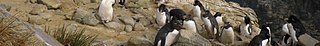
English: Pour atteindre les nids les plus hauts les gorfous doivent gravir "à pattes" 50 m de falaise ! |
|||
Date | ||||
Source | Own work | |||
Author | BluesyPete | |||
Other versions |
|
Camera location | 51° 43′ 02″ S, 61° 18′ 41″ W ![]() | View this and other nearby images on: OpenStreetMap | ![]() |
---|
Licensing
[edit]I, the copyright holder of this work, hereby publish it under the following license:
![w:en:Creative Commons](https://upload.wikimedia.org/wikipedia/commons/thumb/7/79/CC_some_rights_reserved.svg/90px-CC_some_rights_reserved.svg.png)
![attribution](https://upload.wikimedia.org/wikipedia/commons/thumb/1/11/Cc-by_new_white.svg/24px-Cc-by_new_white.svg.png)
![share alike](https://upload.wikimedia.org/wikipedia/commons/thumb/d/df/Cc-sa_white.svg/24px-Cc-sa_white.svg.png)
This file is licensed under the Creative Commons Attribution-Share Alike 3.0 Unported license.
- You are free:
- to share – to copy, distribute and transmit the work
- to remix – to adapt the work
- Under the following conditions:
- attribution – You must give appropriate credit, provide a link to the license, and indicate if changes were made. You may do so in any reasonable manner, but not in any way that suggests the licensor endorses you or your use.
- share alike – If you remix, transform, or build upon the material, you must distribute your contributions under the same or compatible license as the original.
File history
Click on a date/time to view the file as it appeared at that time.
Date/Time | Thumbnail | Dimensions | User | Comment | |
---|---|---|---|---|---|
current | 16:40, 12 February 2018 | ![]() | 2,046 × 292 (345 KB) | Teseo (talk | contribs) | File:SubAntarctique-0191.jpg cropped < 1 % horizontally and 81 % vertically using CropTool with precise mode. |
You cannot overwrite this file.
File usage on Commons
The following 2 pages use this file:
File usage on other wikis
The following other wikis use this file:
- Usage on en.wikivoyage.org
- Usage on eo.wikipedia.org
- Usage on it.wikivoyage.org
- Usage on www.wikidata.org
Metadata
This file contains additional information such as Exif metadata which may have been added by the digital camera, scanner, or software program used to create or digitize it. If the file has been modified from its original state, some details such as the timestamp may not fully reflect those of the original file. The timestamp is only as accurate as the clock in the camera, and it may be completely wrong.
Camera manufacturer | OLYMPUS IMAGING CORP. |
---|---|
Camera model | SP570UZ |
Copyright holder |
|
Exposure time | 1/320 sec (0.003125) |
F-number | f/5.6 |
ISO speed rating | 64 |
Date and time of data generation | 09:27, 7 December 2008 |
Lens focal length | 9.77 mm |
Latitude | 51° 43′ 2″ S |
Longitude | 61° 18′ 41″ W |
Altitude | 32 meters above sea level |
Image title |
|
City shown | La rookerie des gorfous sauteurs |
Orientation | Normal |
Horizontal resolution | 72 dpi |
Vertical resolution | 72 dpi |
Software used | Elements Organizer 9.0 |
File change date and time | 19:21, 11 May 2012 |
Y and C positioning | Co-sited |
Exposure Program | Normal program |
Exif version | 2.21 |
Date and time of digitizing | 09:28, 7 December 2008 |
Meaning of each component |
|
Image compression mode | 4 |
APEX shutter speed | 8.321928 |
APEX aperture | 4.970854 |
APEX exposure bias | 0 |
Maximum land aperture | 2.97 APEX (f/2.8) |
Metering mode | Pattern |
Light source | Unknown |
Flash | Flash did not fire, compulsory flash suppression |
Supported Flashpix version | 1 |
Color space | sRGB |
File source | Digital still camera |
Scene type | A directly photographed image |
Custom image processing | Custom process |
Exposure mode | Auto exposure |
White balance | Auto white balance |
Digital zoom ratio | 0 |
Scene capture type | Standard |
Scene control | None |
Contrast | Normal |
Saturation | Normal |
Sharpness | Normal |
GPS time (atomic clock) | 08:28 |
Satellites used for measurement | 0 |
Geodetic survey data used | WGS-84 |
GPS date | 7 December 2008 |
GPS tag version | 2.2.0.0 |
Date metadata was last modified | 16:40, 19 March 2016 |
Rating (out of 5) | 2 |
Unique ID of original document | uuid:AF8F25D7986FDE119BECB68A5FB48A1B |
Keywords |
|
Code for country shown | FLK |
Sublocation of city shown | New Island Settlement |
Country shown | ÃŽles Malouines |
IIM version | 4 |