File:Wuhan Metro Map of 2017 in English.png
Jump to navigation
Jump to search
Size of this preview: 753 × 600 pixels. Other resolutions: 301 × 240 pixels | 603 × 480 pixels | 964 × 768 pixels | 1,280 × 1,020 pixels | 2,490 × 1,984 pixels.
Original file (2,490 × 1,984 pixels, file size: 337 KB, MIME type: image/png)
Captions
Captions
Add a one-line explanation of what this file represents
Summary
[edit]
| Description |
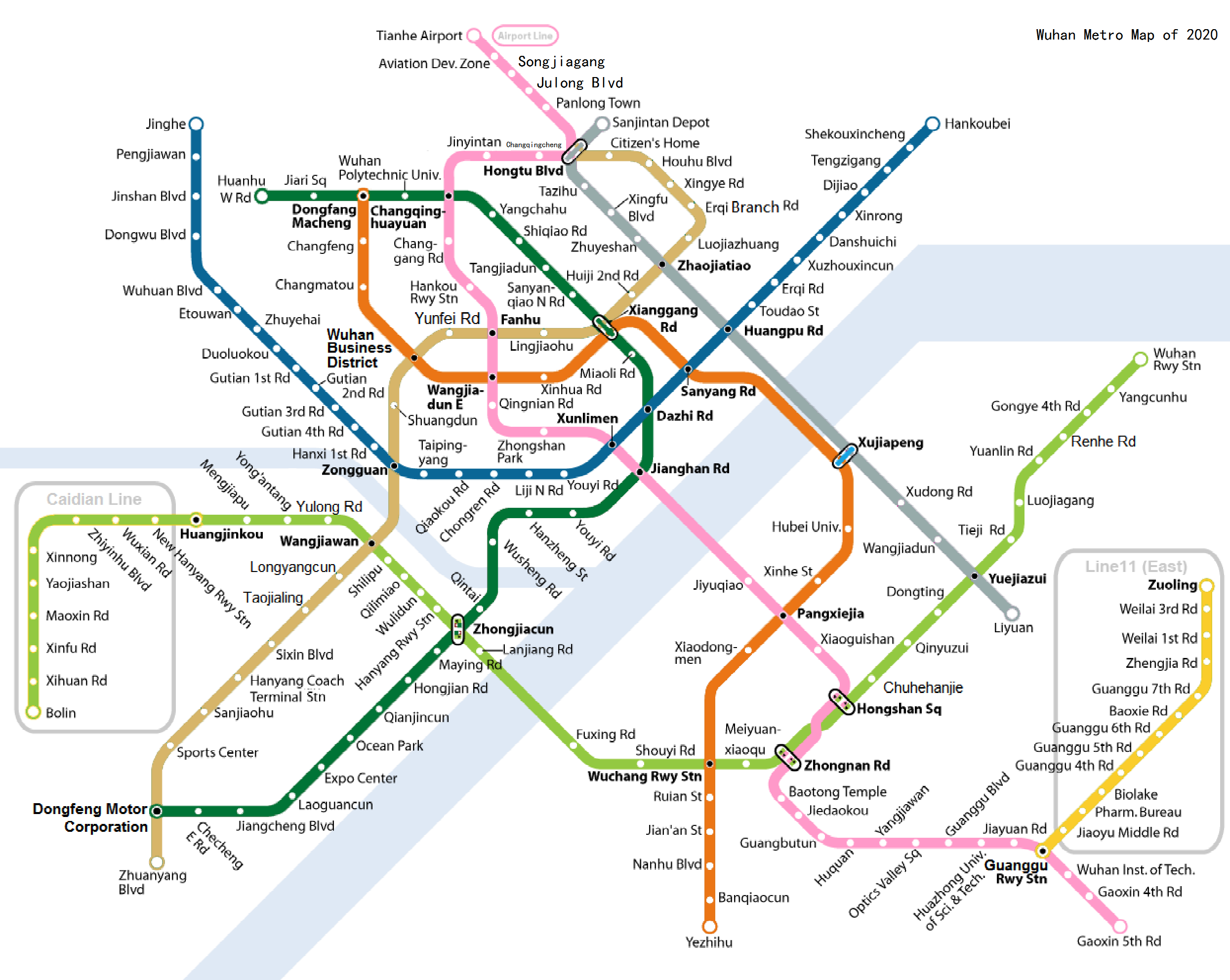
English: Wuhan Metro Map of 2017 in English |
| Date | |
| Source | Own work |
| Author | Howchou |
| Other versions | File:Wuhan Metro Map of 2017 in Chinese.png |
Licensing
[edit]
I, the copyright holder of this work, hereby publish it under the following license:
This file is licensed under the Creative Commons Attribution-Share Alike 3.0 Unported license.
- You are free:
- to share – to copy, distribute and transmit the work
- to remix – to adapt the work
- Under the following conditions:
- attribution – You must give appropriate credit, provide a link to the license, and indicate if changes were made. You may do so in any reasonable manner, but not in any way that suggests the licensor endorses you or your use.
- share alike – If you remix, transform, or build upon the material, you must distribute your contributions under the same or compatible license as the original.
File history
Click on a date/time to view the file as it appeared at that time.
| Date/Time | Thumbnail | Dimensions | User | Comment | |
|---|---|---|---|---|---|
| current | 06:01, 15 November 2016 | | 2,490 × 1,984 (337 KB) | MTR-HK1000 (talk | contribs) | upd |
| 11:28, 11 July 2016 |  | 2,490 × 1,984 (376 KB) | 广州地铁5号线 (talk | contribs) | Big fix | |
| 07:26, 9 July 2016 |  | 1,245 × 992 (190 KB) | 广州地铁5号线 (talk | contribs) | updated | |
| 11:25, 15 October 2015 |  | 1,245 × 992 (230 KB) | Doraemon.tvb (talk | contribs) | update | |
| 21:00, 28 April 2013 |  | 1,245 × 992 (210 KB) | Howchou (talk | contribs) | update | |
| 02:25, 28 April 2013 |  | 1,152 × 943 (175 KB) | Howchou (talk | contribs) | adjust font size | |
| 10:52, 14 January 2013 |  | 1,152 × 943 (198 KB) | Howchou (talk | contribs) | small adjustment | |
| 03:09, 11 January 2013 |  | 1,676 × 1,444 (566 KB) | Howchou (talk | contribs) | small modification | |
| 12:57, 8 January 2013 |  | 1,676 × 1,444 (565 KB) | Howchou (talk | contribs) | small fix | |
| 04:11, 8 January 2013 |  | 1,676 × 1,444 (565 KB) | Howchou (talk | contribs) | minor fix |
You cannot overwrite this file.
File usage on Commons
The following 14 pages use this file:
- User:Chumwa/OgreBot/Potential transport maps/2016 July 1-10
- User:Chumwa/OgreBot/Potential transport maps/2016 July 11-20
- User:Chumwa/OgreBot/Potential transport maps/2016 November 11-20
- User:Chumwa/OgreBot/Public transport information/2015 October 11-20
- User:Chumwa/OgreBot/Public transport information/2016 July 1-10
- User:Chumwa/OgreBot/Public transport information/2016 July 11-20
- User:Chumwa/OgreBot/Public transport information/2016 November 11-20
- User:Chumwa/OgreBot/Transport Maps/2015 October 11-20
- User:Chumwa/OgreBot/Transport Maps/2016 July 1-10
- User:Chumwa/OgreBot/Transport Maps/2016 July 11-20
- User:Chumwa/OgreBot/Transport Maps/2016 November 11-20
- User:Chumwa/OgreBot/Travel and communication maps/2016 July 1-10
- User:Chumwa/OgreBot/Travel and communication maps/2016 July 11-20
- User:Chumwa/OgreBot/Travel and communication maps/2016 November 11-20