File:Wrysgan Quarry map 1889-1919.jpg
Jump to navigation
Jump to search

Size of this preview: 482 × 600 pixels. Other resolutions: 193 × 240 pixels | 386 × 480 pixels | 820 × 1,020 pixels.
Original file (820 × 1,020 pixels, file size: 463 KB, MIME type: image/jpeg)
Captions
Captions
Add a one-line explanation of what this file represents
Summary
[edit]
| Description |
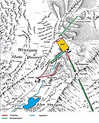
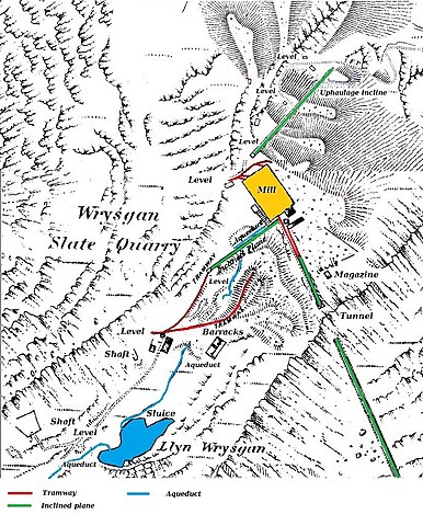
English: A map showing the Wrysgan Quarry. From the mill downwards, it dates from 1889, when the quarry was working, while the top half shows the uphaulage incline, and dates from 1919, when the quarry was closed. |
| Date | |
| Source | Ordnance Survey 1:2500 map, published 1889 (bottom half) and 1919 (top half). |
| Author | UK Government - Ordnance Survey. Coloured overlays by Bob1960evens |
Licensing
[edit]
This work created by the United Kingdom Government is in the public domain.
This is because it is one of the following:
HMSO has declared that the expiry of Crown Copyrights applies worldwide (ref: HMSO Email Reply)
|
 |
This map was published by the Ordnance Survey and is more than 50 years old
File history
Click on a date/time to view the file as it appeared at that time.
| Date/Time | Thumbnail | Dimensions | User | Comment | |
|---|---|---|---|---|---|
| current | 11:17, 29 July 2016 | | 820 × 1,020 (463 KB) | Bob1960evens (talk | contribs) | User created page with UploadWizard |
You cannot overwrite this file.
File usage on Commons
The following 2 pages use this file:
File usage on other wikis
The following other wikis use this file:
- Usage on en.wikipedia.org
- Usage on www.wikidata.org