File:Worthington Farm and Monocacy Location Map (df10cf2b-f0f4-c026-5dc6-e8ec1f0a15d6).jpg
Jump to navigation
Jump to search

Size of this preview: 389 × 599 pixels. Other resolutions: 156 × 240 pixels | 312 × 480 pixels | 499 × 768 pixels | 1,169 × 1,800 pixels.
Original file (1,169 × 1,800 pixels, file size: 229 KB, MIME type: image/jpeg)
Captions
Captions
Add a one-line explanation of what this file represents

|
The categories of this image need checking. You can do so here.
|
.jpg&action=edit&withJS=MediaWiki:Catcheck.js)
Summary
[edit].jpg&action=edit§ion=1)
| English: Worthington Farm and Monocacy Location Map | ||||
|---|---|---|---|---|
| Photographer |
English: NPS |
|||
| Title |
English: Worthington Farm and Monocacy Location Map |
|||
| Publisher |
English: U.S. National Park Service |
|||
| Description |
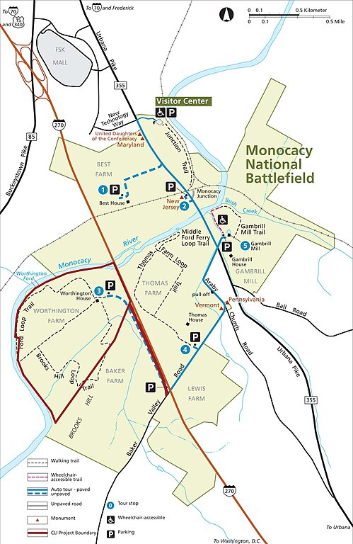
English: A park map shows the Worthington Farm in relationship to other roads and areas of Monocacy. Worthington Farm. Monocacy Battlefield is comprised of six properties: the Baker, Best, Lewis, Thomas, and Worthington Farms, as well as the Gambrill Mill tract. The agricultural landscape served as the stage for the Civil War Battle of Monocacy
|
|||
| Depicted place |
English: 39.36153, -77.40297; Monocacy National Battlefield, Frederick County, Maryland; Latitude: 39.3577003479004, Longitude: -77.4024963378906 |
|||
| Date | Taken on 6 December 2013 | |||
| Accession number | ||||
| Source |
English: NPGallery |
|||
| Permission (Reusing this file) |
|
|||
| NPS Unit Code | MONO | |||
| Album(s) | English: Worthington Farm |
|||
File history
Click on a date/time to view the file as it appeared at that time.
| Date/Time | Thumbnail | Dimensions | User | Comment | |
|---|---|---|---|---|---|
| current | 18:24, 15 May 2024 | | 1,169 × 1,800 (229 KB) | BMacZeroBot (talk | contribs) | Batch upload (Commons:Batch uploading/NPGallery) |
You cannot overwrite this file.
File usage on Commons
The following page uses this file:
.jpg)
.jpg&oldid=911727365)