File:WorldCenterOfPopulation.png
Jump to navigation
Jump to search
Size of this preview: 800 × 493 pixels. Other resolutions: 320 × 197 pixels | 640 × 394 pixels | 1,073 × 661 pixels.
Original file (1,073 × 661 pixels, file size: 141 KB, MIME type: image/png)
Captions
Captions
Add a one-line explanation of what this file represents
Summary
[edit]
| Description |
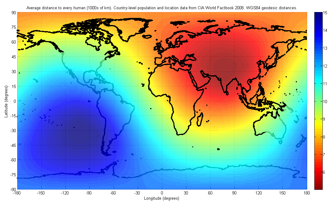
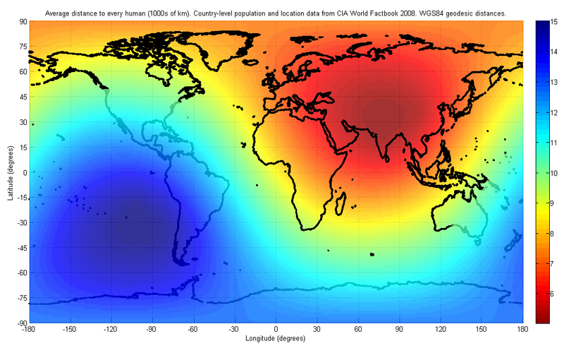
English: The figure indicates the average distance to every human on earth, depending on location. The population and location data used are at the country-level, from the 2008 CIA World Factbook. The distance was computed first by finding the geodesic (shortest path) distance along the surface of the WGS84 reference ellipsoid to each country on the list, and then finding the weighted average of all such distances with the weight being the corresponding country's population.
I have used only publicly available data for this image. The image may look slightly different in future, as world population distributions change. The image will also look different if a different distance metric is used, such as a Euclidean distance in three dimensions, which would allow for tunneling through the earth. |
| Date | |
| Source | Own work |
| Author | Brhaspati |
Licensing
[edit]
I, the copyright holder of this work, hereby publish it under the following licenses:
This file is licensed under the Creative Commons Attribution-Share Alike 3.0 Unported license.
- You are free:
- to share – to copy, distribute and transmit the work
- to remix – to adapt the work
- Under the following conditions:
- attribution – You must give appropriate credit, provide a link to the license, and indicate if changes were made. You may do so in any reasonable manner, but not in any way that suggests the licensor endorses you or your use.
- share alike – If you remix, transform, or build upon the material, you must distribute your contributions under the same or compatible license as the original.

|
Permission is granted to copy, distribute and/or modify this document under the terms of the GNU Free Documentation License, Version 1.2 or any later version published by the Free Software Foundation; with no Invariant Sections, no Front-Cover Texts, and no Back-Cover Texts. A copy of the license is included in the section entitled GNU Free Documentation License. |
You may select the license of your choice.
File history
Click on a date/time to view the file as it appeared at that time.
| Date/Time | Thumbnail | Dimensions | User | Comment | |
|---|---|---|---|---|---|
| current | 18:52, 4 December 2021 | | 1,073 × 661 (141 KB) | JIP (talk | contribs) | Inverted colour hues. Now red means more population density and blue means less. |
| 23:11, 2 June 2008 |  | 1,073 × 661 (144 KB) | Brhaspati (talk | contribs) | {{Information |Description={{en|1=The figure indicates the average distance to every human on earth, depending on location. The population and location data used are at the country-level, from the 2008 CIA World Factbook. The distance was computed first b |
You cannot overwrite this file.
File usage on Commons
The following page uses this file:
File usage on other wikis
The following other wikis use this file:
- Usage on de.wikipedia.org
- Usage on en.wikipedia.org
- Usage on eu.wikipedia.org
- Usage on ja.wikipedia.org
- Usage on ru.wikipedia.org
- Usage on uk.wikipedia.org