File:Worcester Consolidated Street Railway 1908 map.jpg
Jump to navigation
Jump to search

Size of this preview: 606 × 599 pixels. Other resolutions: 243 × 240 pixels | 485 × 480 pixels | 776 × 768 pixels | 1,118 × 1,106 pixels.
Original file (1,118 × 1,106 pixels, file size: 119 KB, MIME type: image/jpeg)
Captions
Captions
Add a one-line explanation of what this file represents
Summary
[edit]| Description |
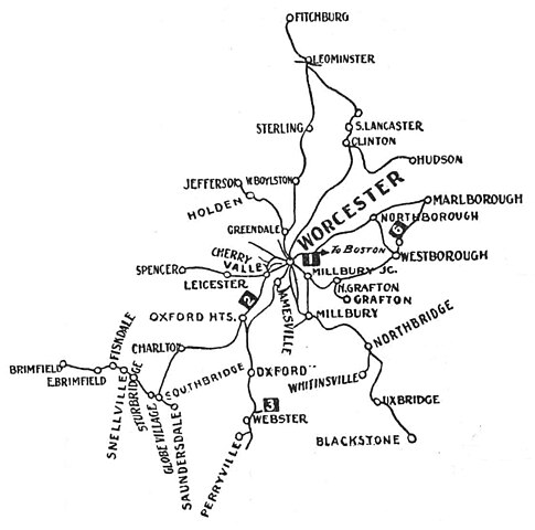
English: 1908 map of what would become the Worcester Consolidated Street Railway system. All lines shown were under control of the New Haven Railroad at the time, but not all were yet placed under control of the Worcester Consolidated. The numbered flags indicate lakes and parks: 1 is Lincoln Park, 2 is Pinehurst Park, 3 is Beacon Park, and 6 is Lake Chauncey. |
| Date | |
| Source |
Scanned file from private collection Originally published in The Trolley Wayfinder, 1908 |
| Author | Unknown author |
| Other versions |

Licensing
[edit]
This image is in the public domain because it is a mere mechanical scan or photocopy of a public domain original, or – from the available evidence – is so similar to such a scan or photocopy that no copyright protection can be expected to arise. The original itself is in the public domain for the following reason:
This tag is designed for use where there may be a need to assert that any enhancements (eg brightness, contrast, colour-matching, sharpening) are in themselves insufficiently creative to generate a new copyright. It can be used where it is unknown whether any enhancements have been made, as well as when the enhancements are clear but insufficient. For known raw unenhanced scans you can use an appropriate {{PD-old}} tag instead. For usage, see Commons:When to use the PD-scan tag.  |
File history
Click on a date/time to view the file as it appeared at that time.
| Date/Time | Thumbnail | Dimensions | User | Comment | |
|---|---|---|---|---|---|
| current | 20:03, 10 May 2024 | | 1,118 × 1,106 (119 KB) | Pi.1415926535 (talk | contribs) | show only WCSR lines |
| 19:58, 10 May 2024 |  | 1,333 × 1,289 (166 KB) | Pi.1415926535 (talk | contribs) | File:Consolidated System 1908 map.jpg cropped 57 % horizontally, 49 % vertically using CropTool with precise mode. |
You cannot overwrite this file.
File usage on Commons
The following 5 pages use this file: