File:Woodhead Tunnel westward from above 2048315 ad72ea83.jpg
Jump to navigation
Jump to search
No higher resolution available.
Woodhead_Tunnel_westward_from_above_2048315_ad72ea83.jpg (640 × 403 pixels, file size: 155 KB, MIME type: image/jpeg)
Captions
Captions
Add a one-line explanation of what this file represents
Summary
[edit]
| Description |
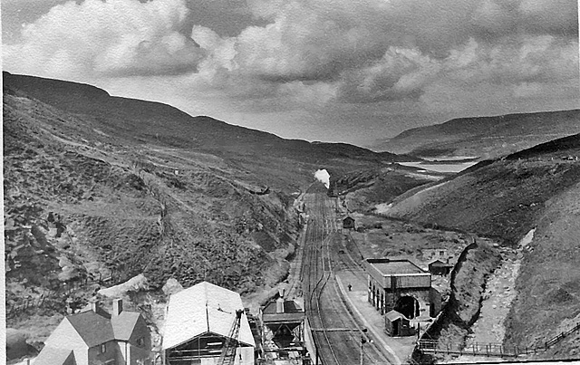
English: Westward from above Woodhead Tunnel. View from A628 in 1951, when the ex-Great Central Sheffield (Victoria) - Manchester main line was not only still running, but having a New Woodhead Tunnel being built for it , prior to the whole route being electrified. (See SK1199 : Westward view at Woodhead, SK1199 : Locomotive (Derailed) and other scenes submitted together Shared Description). In this view the new tunnel portal is below to left and the new Woodhead Station will be built on this alignment. The new station was opened with the New Tunnel and the initiation of full electrification on 14/6/54, the Old (single-bore) Tunnels and Station being closed simultaneously. Here the main lines disappear towards Manchester (an Up freight blows off in the Up Loop), beside the River Etherow, which leads into the reservoirs down Longdendale. |
| Date | |
| Source | From geograph.org.uk |
| Author | Ben Brooksbank |
| Permission (Reusing this file) |
Creative Commons Attribution Share-alike license 2.0 |
| Attribution (required by the license) | Ben Brooksbank / Westward from above Woodhead Tunnel / |
| Camera location | | View this and other nearby images on: OpenStreetMap |
|---|
Licensing
[edit]

|
This image was taken from the Geograph project collection. See this photograph's page on the Geograph website for the photographer's contact details. The copyright on this image is owned by Ben Brooksbank and is licensed for reuse under the Creative Commons Attribution-ShareAlike 2.0 license.
|
This file is licensed under the Creative Commons Attribution-Share Alike 2.0 Generic license.
Attribution: Ben Brooksbank
- You are free:
- to share – to copy, distribute and transmit the work
- to remix – to adapt the work
- Under the following conditions:
- attribution – You must give appropriate credit, provide a link to the license, and indicate if changes were made. You may do so in any reasonable manner, but not in any way that suggests the licensor endorses you or your use.
- share alike – If you remix, transform, or build upon the material, you must distribute your contributions under the same or compatible license as the original.
File history
Click on a date/time to view the file as it appeared at that time.
| Date/Time | Thumbnail | Dimensions | User | Comment | |
|---|---|---|---|---|---|
| current | 16:11, 20 January 2011 | | 640 × 403 (155 KB) | Belaro (talk | contribs) | == {{int:filedesc}} == {{Information |Description={{en|1=Westward from above Woodhead Tunnel View from A628 in 1951, when the ex-Great Central Sheffield (Victoria) - Manchester main line was not only still running, but having a New Woodhead Tunnel being b |
You cannot overwrite this file.
File usage on Commons
There are no pages that use this file.