File:Women's Work, Bilston (53579057248).jpg
Jump to navigation
Jump to search

Size of this preview: 441 × 599 pixels. Other resolutions: 177 × 240 pixels | 353 × 480 pixels | 566 × 768 pixels | 754 × 1,024 pixels | 1,508 × 2,048 pixels | 3,718 × 5,048 pixels.
Original file (3,718 × 5,048 pixels, file size: 2.41 MB, MIME type: image/jpeg)
Captions
Captions
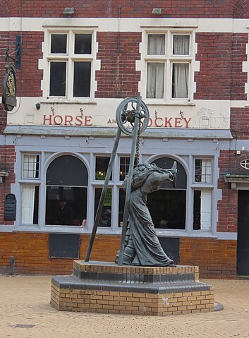
Women's Work is a bronze statue in Bilston outside Horse and Jockey pub
Summary
[edit].jpg&action=edit§ion=1)
| Description |
English: In Bilston Town Centre. Just passing from The Crescent Tram Stop to Bilston Central Tram Stop, so didn't stop to have much of a look of the High Street again.
Was also going to other tram stops in West Bromwich on the way down from Wolverhampton. The Women's Work bronze statue by the Horse and Jockey pub. Between International Women's Day and Mothers Day (Mothering Sunday). Women's Work sculpture near the top of Church Street in Bilston. Outside of the Horse and Jockey pub. By Rose Garrard, 1996 - 1998. Commissioned by Blue Lamp Business Parks Ltd. A maquette was made for an exhibition in 1995 and the full scale model in 1997. This four metre high bronze sculpture by Rose Garrard of a female figure beside a pit-head gantry, commemorates the impoverished women working in the 19th century coal and iron industries of the Black Country. It can be seen in Bilston High Street close to the site of a ‘fold’, a cluster of small hovels where families lived and the women repetitively forged tiny items such as nails, chain links and pulleys, selling them to merchants to survive. These items have been fused into the clothing of this metamorphic figure, whose head is the small anvil and her forearms the tongs used for holding the hot metal. Her feet are flat irons, while the back of her skirt is composed of stacked cooking pots. Local women were later employed in nearby factories making cast iron cooking pots and flat irons as well as in large laundries where they put the irons to use. The figure is stooped over to support her burden of coal, the constant position of a ‘pit-bank wench’ paid to work bowed down all day to reclaim any usable lumps of coal from the slag heaps at the pit head. |
| Date | |
| Source | https://www.flickr.com/photos/ell-r-brown/53579057248/ |
| Author | Elliott Brown |
| Camera location | | View this and other nearby images on: OpenStreetMap |
|---|
.jpg¶ms=052.565688_N_-002.076137_E_globe:Earth_type:camera__&language=en)
Licensing
[edit].jpg&action=edit§ion=2)
This file is licensed under the Creative Commons Attribution-Share Alike 2.0 Generic license.
- You are free:
- to share – to copy, distribute and transmit the work
- to remix – to adapt the work
- Under the following conditions:
- attribution – You must give appropriate credit, provide a link to the license, and indicate if changes were made. You may do so in any reasonable manner, but not in any way that suggests the licensor endorses you or your use.
- share alike – If you remix, transform, or build upon the material, you must distribute your contributions under the same or compatible license as the original.
| This image was originally posted to Flickr by ell brown at https://flickr.com/photos/39415781@N06/53579057248. It was reviewed on 13 March 2024 by FlickreviewR 2 and was confirmed to be licensed under the terms of the cc-by-sa-2.0. |
File history
Click on a date/time to view the file as it appeared at that time.
| Date/Time | Thumbnail | Dimensions | User | Comment | |
|---|---|---|---|---|---|
| current | 16:43, 10 March 2024 | | 3,718 × 5,048 (2.41 MB) | Ellrbrown (talk | contribs) | Uploaded a work by Elliott Brown from https://www.flickr.com/photos/ell-r-brown/53579057248/ with UploadWizard |
You cannot overwrite this file.
File usage on Commons
There are no pages that use this file.
.jpg&oldid=888843310)