File:Winterthur Battle 1799 de.svg
Jump to navigation
Jump to search

Size of this PNG preview of this SVG file: 495 × 600 pixels. Other resolutions: 198 × 240 pixels | 396 × 480 pixels | 634 × 768 pixels | 845 × 1,024 pixels | 1,690 × 2,048 pixels | 826 × 1,001 pixels.
Original file (SVG file, nominally 826 × 1,001 pixels, file size: 354 KB)
Captions
Captions
Add a one-line explanation of what this file represents
| Description |
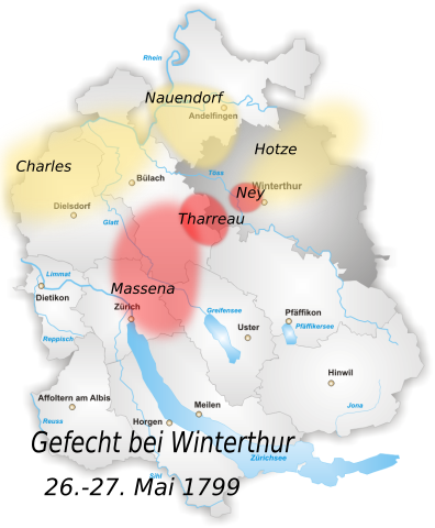
District of Winterthur Map drawn by Tschubby German version of the map of the "Battle of Winterthur" |
| Date | (UTC) |
| Source | |
| Author |
|
I, the copyright holder of this work, hereby publish it under the following licenses:
| This file is licensed under the Creative Commons Attribution-Share Alike 3.0 Unported license. | ||
| ||
| This licensing tag was added to this file as part of the GFDL licensing update. |

|
Permission is granted to copy, distribute and/or modify this document under the terms of the GNU Free Documentation License, Version 1.2 or any later version published by the Free Software Foundation; with no Invariant Sections, no Front-Cover Texts, and no Back-Cover Texts. A copy of the license is included in the section entitled GNU Free Documentation License. |
You may select the license of your choice.
Original upload log
[edit]
This image is a derivative work of the following images:
- File:Winterthur_Battle_1799.svg licensed with Cc-by-sa-3.0-migrated, GFDL
- 2010-01-13T10:41:44Z Fundriver 826x1001 (362633 Bytes) Reverted to version as of 10:34, 13 January 2010
- 2010-01-13T10:41:20Z Fundriver 826x1001 (362633 Bytes) ...
- 2010-01-13T10:34:36Z Fundriver 826x1001 (362633 Bytes) "Schaffhausen" erased (this is a map of the canton of Zurich).
- 2009-12-29T03:26:14Z Auntieruth55 826x1001 (363017 Bytes) {{Information |Description=District of Winterthur Map drawn by [[:de:Benutzer:Tschubby|Tschubby]] |Source=*[[:File:Karte_Bezirk_Winterthur.png|]] |Date=2009-12-29 03:22 (UTC) |Author=*[[:File:Karte_Bezirk_Winterthur.png|]]:
Uploaded with derivativeFX
File history
Click on a date/time to view the file as it appeared at that time.
| Date/Time | Thumbnail | Dimensions | User | Comment | |
|---|---|---|---|---|---|
| current | 16:37, 28 October 2012 | | 826 × 1,001 (354 KB) | Fundriver (talk | contribs) | Reverted to version as of 11:51, 13 January 2010 |
| 16:37, 28 October 2012 |  | 845 × 1,001 (426 KB) | Fundriver (talk | contribs) | aktualisiert | |
| 11:51, 13 January 2010 |  | 826 × 1,001 (354 KB) | Fundriver (talk | contribs) | {{Information |Description=District of Winterthur Map drawn by Tschubby German version of the map of the "Battle of Winterthur" |Source=*File:Winterthur_Battle_1799.svg |Date=2010-01-13 10:50 (UTC) |Author=*[[:File:Winte |
You cannot overwrite this file.
File usage on Commons
There are no pages that use this file.
File usage on other wikis
The following other wikis use this file:
- Usage on de.wikipedia.org