File:Winterliche Stimmung beim Geotop Buckelwiesen Nördlich von Mittenwald.jpg
Jump to navigation
Jump to search
Size of this preview: 400 × 599 pixels. Other resolutions: 160 × 240 pixels | 320 × 480 pixels | 512 × 768 pixels | 683 × 1,024 pixels | 1,367 × 2,048 pixels | 4,166 × 6,242 pixels.
Original file (4,166 × 6,242 pixels, file size: 13.88 MB, MIME type: image/jpeg)
Captions
Captions
Add a one-line explanation of what this file represents
Summary
[edit]
| Description |
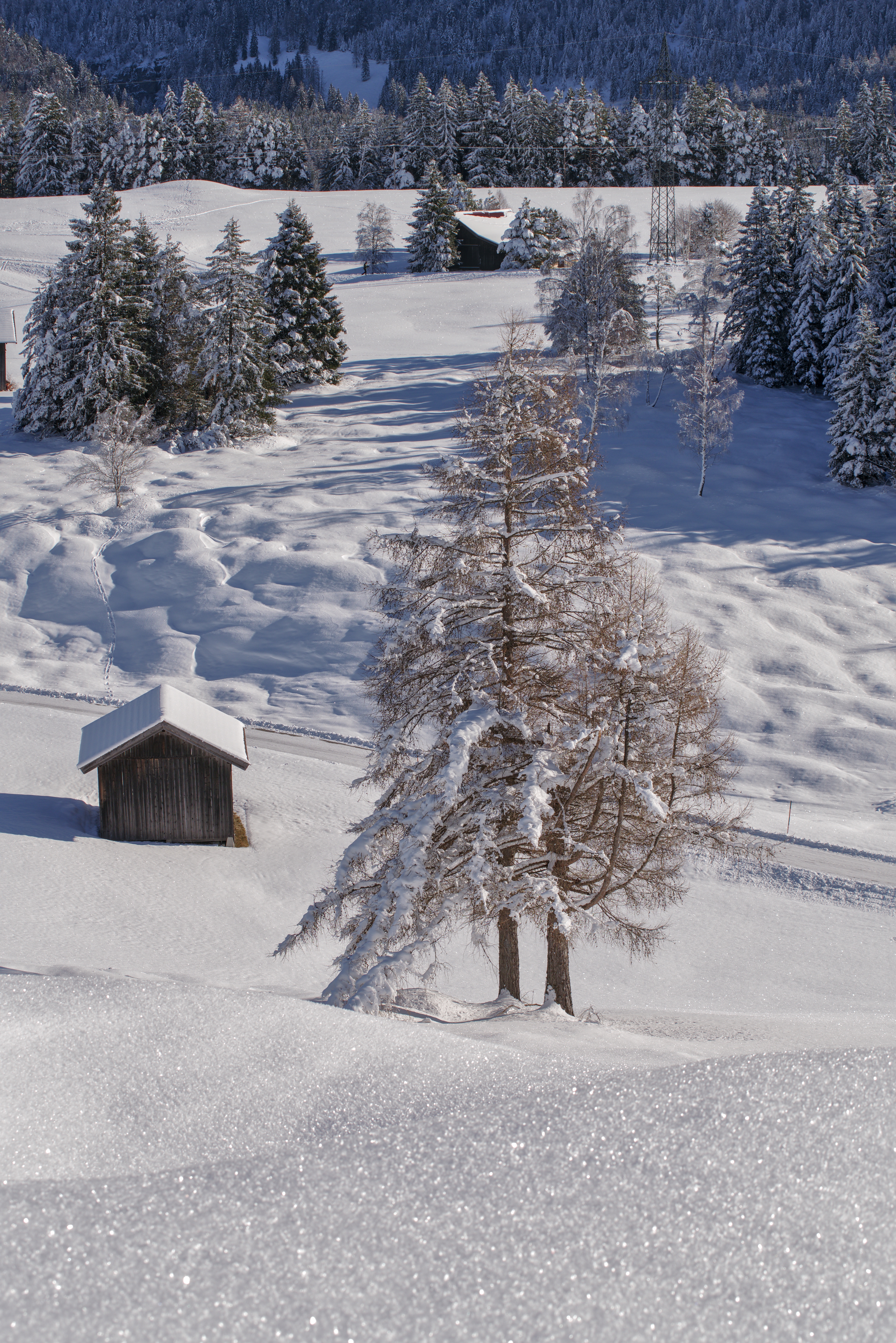
Deutsch: Der Höhenrücken zwischen Mittenwald, Klais und Krün liegt auf Grundmoränen und darunter liegenden Schotter- und See-Ablagerungen der letzten Eiszeit. Auf diesem kalkreichen Untergrund entwickelte sich eine zusammenhängende Buckelflur aus unzähligen einzelnen Hügel von 50-100 Zentimeter Höhe. Die wellige Oberfläche war für eine intensive landwirtschaftliche Nutzung hinderlich, deshalb wurden ab 1920 große Teile der Buckelwiesen eingeebnet. Vor allem in Gräben und an steileren Hängen blieben aber noch größere Bereiche erhalten. Besonders eindrucksvoll ist das Nebeneinander eingeebneter und erhaltener Buckelwiesen.
Die Restbestände stellen nicht nur eine landschaftliche Besonderheit dar, sondern sind auch sehr artenreich. Um diese Kostbarkeit zu erhalten, werden die Wiesen heute nicht mehr eingeebnet, nicht gedüngt und nur mehr extensiv bewirtschaftet. Die Buckelwiesen sind Geotop und FFH-Gebiet. Das Geotop wurde vom Bayerischen Landesamt für Umwelt mit dem Gütesiegel "Bayerns 100 schönste Geotope" ausgezeichnet. |
| Date | |
| Source | Own work |
| Author | Jan Czeczotka |
| Camera location | | View this and other nearby images on: OpenStreetMap |
|---|
Licensing
[edit]
I, the copyright holder of this work, hereby publish it under the following license:
This file is licensed under the Creative Commons Attribution-Share Alike 4.0 International license.
- You are free:
- to share – to copy, distribute and transmit the work
- to remix – to adapt the work
- Under the following conditions:
- attribution – You must give appropriate credit, provide a link to the license, and indicate if changes were made. You may do so in any reasonable manner, but not in any way that suggests the licensor endorses you or your use.
- share alike – If you remix, transform, or build upon the material, you must distribute your contributions under the same or compatible license as the original.
This image was uploaded as part of Wiki Loves Earth 2024.
|
 |
File history
Click on a date/time to view the file as it appeared at that time.
| Date/Time | Thumbnail | Dimensions | User | Comment | |
|---|---|---|---|---|---|
| current | 11:54, 21 May 2024 | | 4,166 × 6,242 (13.88 MB) | Mölchlein (talk | contribs) | Uploaded own work with UploadWizard |
You cannot overwrite this file.
File usage on Commons
There are no pages that use this file.
File usage on other wikis
The following other wikis use this file:
- Usage on de.wikipedia.org