File:Winchester, the butter cross - geograph.org.uk - 1556842.jpg
Jump to navigation
Jump to search
No higher resolution available.
Winchester,_the_butter_cross_-_geograph.org.uk_-_1556842.jpg (640 × 427 pixels, file size: 202 KB, MIME type: image/jpeg)
Captions
Captions
Add a one-line explanation of what this file represents
Summary
[edit]
| Description |
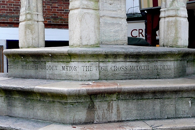
English: Winchester, the butter cross. On the riser of the top of five octagonal steps is this inscription:
Restored Anno Domini MDCCCLXV : William Budden Mayor The High Cross MCDXXII - MCDLXI This indicates that the High Cross, or Buttercross as it is more usually known today, was probably erected between 1422 and 1461 and was restored in 1865. The restorer was the Victorian Gothich Architect George Gilbert Scott, although his name is ignored. But the Mayor of the time has to have a look in of course. For another view see 1556838 and for the context see 1556823 |
| Date | |
| Source | From geograph.org.uk |
| Author | Graham Horn |
| Attribution (required by the license) | Graham Horn / Winchester, the butter cross / |
| Camera location | | View this and other nearby images on: OpenStreetMap |
|---|
_heading:157.00&language=en)
| Object location | | View this and other nearby images on: OpenStreetMap |
|---|
_heading:157.00&language=en)
Licensing
[edit]

|
This image was taken from the Geograph project collection. See this photograph's page on the Geograph website for the photographer's contact details. The copyright on this image is owned by Graham Horn and is licensed for reuse under the Creative Commons Attribution-ShareAlike 2.0 license.
|
This file is licensed under the Creative Commons Attribution-Share Alike 2.0 Generic license.
Attribution: Graham Horn
- You are free:
- to share – to copy, distribute and transmit the work
- to remix – to adapt the work
- Under the following conditions:
- attribution – You must give appropriate credit, provide a link to the license, and indicate if changes were made. You may do so in any reasonable manner, but not in any way that suggests the licensor endorses you or your use.
- share alike – If you remix, transform, or build upon the material, you must distribute your contributions under the same or compatible license as the original.
File history
Click on a date/time to view the file as it appeared at that time.
| Date/Time | Thumbnail | Dimensions | User | Comment | |
|---|---|---|---|---|---|
| current | 15:09, 3 March 2011 | | 640 × 427 (202 KB) | GeographBot (talk | contribs) | == {{int:filedesc}} == {{Information |description={{en|1=Winchester, the butter cross On the riser of the top of five octagonal steps is this inscription: Restored Anno Domini MDCCCLXV : William Budden Mayor The High Cross MCDXXII - MCDLXI This indicate |
You cannot overwrite this file.
File usage on Commons
There are no pages that use this file.