File:Wimbleball Reservoir - geograph.org.uk - 127171.jpg
Jump to navigation
Jump to search
No higher resolution available.
Wimbleball_Reservoir_-_geograph.org.uk_-_127171.jpg (640 × 435 pixels, file size: 459 KB, MIME type: image/jpeg)
Captions
Captions
Add a one-line explanation of what this file represents
Summary
[edit]
| Description |
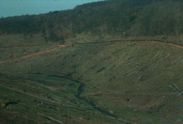
English: Wimbleball Reservoir.This little valley is now underwater. The picture was taken shortly before it was flooded, with all the conifers that grew in the valley, cut down ready for hauling out. It was a curious sensation standing at the planned waters edge looking into a space, the space of the photo and more, that was about to be transformed for the purpose of attracting more people to live in the West Country. Did those additional houses that were able to be built, account for all the water stored in this space? Or did the rain refuse to fill it? Is it a half-filled, or half-empty space today? |
| Date | |
| Source | From geograph.org.uk |
| Author | Mike Leggett |
| Permission (Reusing this file) |
Creative Commons Attribution Share-alike license 2.0 |
| Camera location | | View this and other nearby images on: OpenStreetMap |
|---|
Licensing
[edit]

|
This image was taken from the Geograph project collection. See this photograph's page on the Geograph website for the photographer's contact details. The copyright on this image is owned by Mike Leggett and is licensed for reuse under the Creative Commons Attribution-ShareAlike 2.0 license.
|
This file is licensed under the Creative Commons Attribution-Share Alike 2.0 Generic license.
Attribution: Mike Leggett
- You are free:
- to share – to copy, distribute and transmit the work
- to remix – to adapt the work
- Under the following conditions:
- attribution – You must give appropriate credit, provide a link to the license, and indicate if changes were made. You may do so in any reasonable manner, but not in any way that suggests the licensor endorses you or your use.
- share alike – If you remix, transform, or build upon the material, you must distribute your contributions under the same or compatible license as the original.
File history
Click on a date/time to view the file as it appeared at that time.
| Date/Time | Thumbnail | Dimensions | User | Comment | |
|---|---|---|---|---|---|
| current | 05:47, 31 January 2010 | | 640 × 435 (459 KB) | GeographBot (talk | contribs) | == {{int:filedesc}} == {{Information |description={{en|1=Wistlandpound Reservoir. This little valley is now underwater. The picture was taken shortly before it was flooded, with all the conifers that grew in the valley, cut down ready for hauling out. It |
You cannot overwrite this file.
File usage on Commons
There are no pages that use this file.