File:Willibrordkerk Utrecht.jpg
Jump to navigation
Jump to search

Size of this preview: 450 × 600 pixels. Other resolutions: 180 × 240 pixels | 360 × 480 pixels | 576 × 768 pixels | 768 × 1,024 pixels | 2,112 × 2,816 pixels.
Original file (2,112 × 2,816 pixels, file size: 2.72 MB, MIME type: image/jpeg)
Captions
Captions
Add a one-line explanation of what this file represents
Summary
[edit]
| Description |
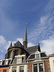
Nederlands: Bovenkant van de nl:Sint-Willibrordkerk (Utrecht), die deels is ingebouwd tussen omringende woningen. Foto gemaakt vanaf Jansdam
|
||||
| Date | |||||
| Source | Own work | ||||
| Author | Luctor |
Licensing
[edit]
| I, the copyright holder of this work, release this work into the public domain. This applies worldwide. In some countries this may not be legally possible; if so: I grant anyone the right to use this work for any purpose, without any conditions, unless such conditions are required by law. |
File history
Click on a date/time to view the file as it appeared at that time.
| Date/Time | Thumbnail | Dimensions | User | Comment | |
|---|---|---|---|---|---|
| current | 13:52, 23 July 2008 | | 2,112 × 2,816 (2.72 MB) | Luctor (talk | contribs) | {{Information |Description={{nl|Bovenkant van de nl:Sint-Willibrordkerk (Utrecht), die deels is ingebouwd tussen omringende woningen. Foto gemaakt vanaf Jansdam}} {{location dms|52|5|33.04776128559297|N|5|7|18.852310180664062|E}} |Source=Eigen werk/o |
You cannot overwrite this file.
File usage on Commons
There are no pages that use this file.