File:Willem Goeree, t Beloofde Landt Canaan met de Reysen Israels door de Woestyne (FL6880700 2368576).jpg
Jump to navigation
Jump to search

Size of this preview: 800 × 511 pixels. Other resolutions: 320 × 204 pixels | 640 × 408 pixels | 1,024 × 653 pixels | 1,280 × 817 pixels | 3,029 × 1,933 pixels.
Original file (3,029 × 1,933 pixels, file size: 3.46 MB, MIME type: image/jpeg)
Captions
Captions
Add a one-line explanation of what this file represents
Summary
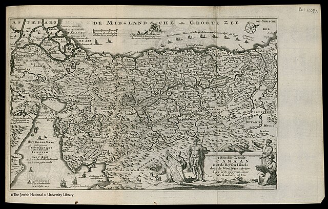
[edit]| Willem Goeree: t Beloofde Landt Canaan met de Reysen Israels door de Woestyne
( |
||||||||||||||||||||||||
|---|---|---|---|---|---|---|---|---|---|---|---|---|---|---|---|---|---|---|---|---|---|---|---|---|
| Artist |
| |||||||||||||||||||||||
| Contributors | Cunaeus, Petrus, 1586-1638 | |||||||||||||||||||||||
| Title |
t Beloofde Landt Canaan met de Reysen Israels door de Woestyne |
|||||||||||||||||||||||
| Description |
t Beloofde Landt Canaan met de Reysen Israels door de Woestyne. door W.Goeree 1683. |
|||||||||||||||||||||||
| Language | Dutch | |||||||||||||||||||||||
| Publication date | 1683 | |||||||||||||||||||||||
| Dimensions | height: 131 mm (5.15 in); width: 205 mm (8.07 in) | |||||||||||||||||||||||
| Collection |
|
|||||||||||||||||||||||
| Current location |
|
|||||||||||||||||||||||
| Place of publication | Amsterdam | |||||||||||||||||||||||
| search Merhav catalog | Amsterdam | |||||||||||||||||||||||
| Notes | Copperplate; From: Cunaeus, p., De Republyk der Hebreen. Amsterdam, Willem Goeree, 1683, Vol. III., between pp. 132-133. 71 B 2325.; The map is drawn after Visscher's original on a reduced scale | |||||||||||||||||||||||
| IE PID | IE6880692 | |||||||||||||||||||||||
| Rosetta filename | FL6880700 | |||||||||||||||||||||||
| NNL item ID (P3959) | 990023685760205171 | |||||||||||||||||||||||
| search Merhav catalog | Dutch, Willem Goeree | |||||||||||||||||||||||
| search Merhav catalog | Exodus, TheMaps | |||||||||||||||||||||||
| Source/Photographer |
|
|||||||||||||||||||||||
| Other versions | ||||||||||||||||||||||||
| Jpg / Tif version |
|
|||||||||||||||||||||||


.jpg)

.jpg&action=edit§ion=1)
Licensing
[edit].jpg&action=edit§ion=2)
The copyright situation of this work is theoretically uncertain, because in the country of origin copyright lasts 70 years after the death of the author, and the date of the author's death is unknown. However, the date of creation of the work was over 120 years ago, and it is thus a reasonable assumption that the copyright has expired (see here for the community discussion). Do not use this template if the date of death of the author is known.
| |
| This file has been identified as being free of known restrictions under copyright law, including all related and neighboring rights. | |
File history
Click on a date/time to view the file as it appeared at that time.
| Date/Time | Thumbnail | Dimensions | User | Comment | |
|---|---|---|---|---|---|
| current | 12:52, 28 July 2023 | | 3,029 × 1,933 (3.46 MB) | Geagea (talk | contribs) | pattypan 22.03 |
You cannot overwrite this file.
File usage on Commons
The following page uses this file:
.jpg&oldid=790292839)