File:Wildbanngrenze Kurpfalz-Speyer 1548.jpg
Jump to navigation
Jump to search

Size of this preview: 103 × 595 pixels. Other resolutions: 41 × 240 pixels | 83 × 480 pixels | 132 × 768 pixels | 1,047 × 6,052 pixels.
Original file (1,047 × 6,052 pixels, file size: 837 KB, MIME type: image/jpeg)
Captions
Captions
Add a one-line explanation of what this file represents
| Description |
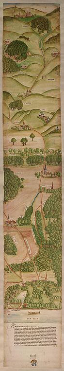
Deutsch: DWildbanngrenze zwischen der Kurpfalz und dem Hochstift Speyer, 1548 (GLAK H-f 1108)
English: Engraving signed by one Wolf Reuss in 1548 showing the border line between the Palatinate of the Rhine and the Prince-Bishopric of Speyer from Lussheim am Rhein to Zuzenhausen in the Kraichgau. |
| Date | |
| Source | http://www.leo-bw.de/web/guest/themen/landesgeschichte/pfalzgrafen-bei-rhein |
| Author | Wolf Reuss |
|
This work is in the public domain in its country of origin and other countries and areas where the copyright term is the author's life plus 100 years or fewer. | |
| This file has been identified as being free of known restrictions under copyright law, including all related and neighboring rights. | |
File history
Click on a date/time to view the file as it appeared at that time.
| Date/Time | Thumbnail | Dimensions | User | Comment | |
|---|---|---|---|---|---|
| current | 08:26, 30 April 2012 | 1,047 × 6,052 (837 KB) | AndreasPraefcke (talk | contribs) | {{Information |Description=Wildbanngrenze zwischen der Kurpfalz und dem Hochstift Speyer, 1548 (GLAK H-f 1108) |Source=http://www.leo-bw.de/web/guest/themen/landesgeschichte/pfalzgrafen-bei-rhein |Date=1548 |Author={{unknown}} |Permission= |other_versi... |
You cannot overwrite this file.
File usage on Commons
There are no pages that use this file.
File usage on other wikis
The following other wikis use this file:
- Usage on de.wikipedia.org
- Usage on en.wikipedia.org
- Usage on fr.wikipedia.org
Metadata
Categories:
- 1548 in art
- 1540s maps of Rhein-Neckar-Kreis
- Palatinate
- Maps of the Prince-Bishopric of Speyer
- Rhine in art
- Zuzenhausen
- Rauenberg
- Dielheim
- Maps of Malsch (bei Heidelberg)
- Maps of Reilingen
- 1548 in Reilingen
- Geography of St. Leon-Rot
- 1548 in St. Leon-Rot
- Altlußheim in the 16th century
- Collections of Generallandesarchiv Karlsruhe