File:Wien Stadtplan 1892 Ausschnitt.jpg

Original file (1,275 × 1,744 pixels, file size: 677 KB, MIME type: image/jpeg)
Captions
Captions
Summary
[edit]
| Description |
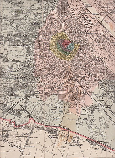
English: Part of a map showing the development of the City of Vienna from the Middle Ages till 1892, when the districts 11 to 19 were created by incorporating suburbs. Gürtelstrasse to be seen as well as the Linienwall fortification (to be pulled down from 1894). Published by the Municipality of Vienna.
Deutsch: Ausschnitt aus einem um 1892 vom Wiener Magistrat publizierten Stadtplan, der die Entwicklungsphasen Wiens vom 12. Jahrhundert (rot) über die Eingemeindung der Vorstädte 1850 (rosa) bis zur Eingemeindung der Vororte 1892 (blau schraffiert) zeigt. Man sieht die bereits bestehenden Teile der Gürtelstraße und den erst ab 1894 abgetragenen Linienwall. |
| Date | |
| Source | Oertliche Entwicklung der Stadt Wien vom Mittelalter bis zur Gegenwart. Nach amtlichen Quellen bearbeitet von Conrad Grefe. Verlag des Wiener Magistrates. Wien 1892 |
| Author | Conrad Grefe |
Licensing
[edit]
|
This work is in the public domain in its country of origin and other countries and areas where the copyright term is the author's life plus 70 years or fewer.
| |
| This file has been identified as being free of known restrictions under copyright law, including all related and neighboring rights. | |
File history
Click on a date/time to view the file as it appeared at that time.
| Date/Time | Thumbnail | Dimensions | User | Comment | |
|---|---|---|---|---|---|
| current | 14:03, 5 March 2010 | | 1,275 × 1,744 (677 KB) | Wolfgang J. Kraus~commonswiki (talk | contribs) | {{Information |Description={{en|1=Part of a map showing the development of the City of Vienna from the Middle Ages till 1892, when the districts 11 to 19 were created by incorporating suburbs. Published by the Municipality of Vienna. }} {{de|1=Ausschnitt |
You cannot overwrite this file.
File usage on Commons
There are no pages that use this file.
File usage on other wikis
The following other wikis use this file:
- Usage on de.wikipedia.org