File:Widespread Smoke across Far Eastern Russia (MODIS 2024-07-15).jpg

Original file (5,660 × 4,554 pixels, file size: 4.3 MB, MIME type: image/jpeg)
Captions
Captions
Summary
[edit].jpg&action=edit§ion=1)
| Description |
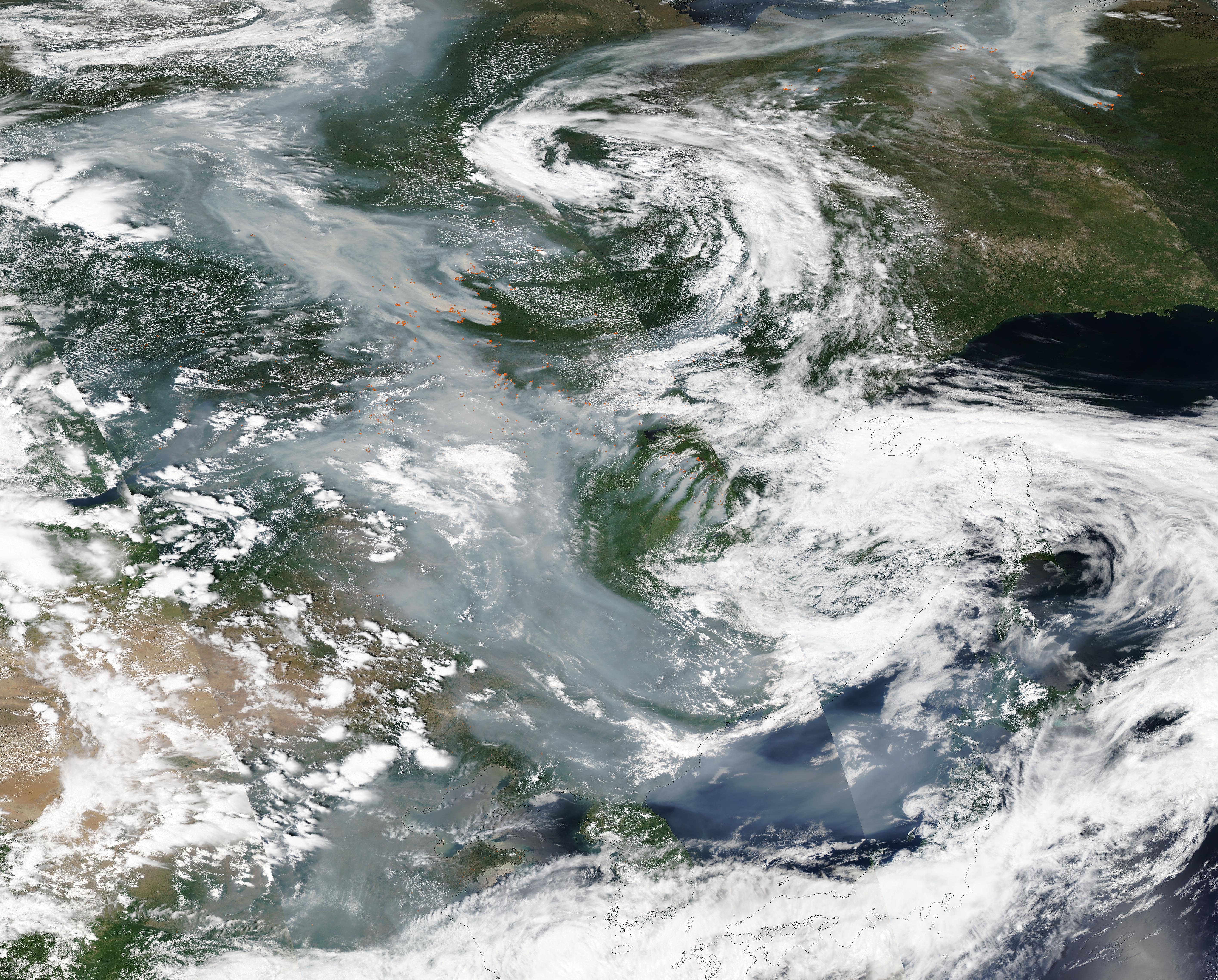
English: Large numbers of intense, smoky fires spread across eastern Russia in the summer of 2024, shrouding the region’s skies, forests, and communities in smoke. Some of the most active areas include Yakutia (Sakha Republic), the country’s largest republic, and the Amur oblast, which borders China’s Heilongjiang province.
On July 11, the Moderate Resolution Imaging Spectroradiometer (MODIS) on NASA’s Aqua satellite acquired a true-color image of smoke pouring from many dozens, if not hundreds, of fires burning across eastern Russia. The smoke reaches far northward to the Laptev Sea (north of the edge of this image) and curls southeastward to shroud northeastern China and the Korean Peninsula. Each red “hot spot” marks actively burning fire. On July 10, 2024, Russia’s Federal Forestry Agency reported that 44 fires were actively burning across 23,000 hectares (90 square miles) in the Amur oblast. Amur is one of eight areas in Russia that have declared a state of emergency due to fires. Other areas with large numbers of fires include Zabaikalsky Krai and the Republic of Sakha (Yakutia), the agency reported. On July 2, the Global Fire Monitoring Center (GFMC) advised that widespread fires led to the republics of Tuva and Yakutia (Sakha) declaring states of emergency. More than 100 wildfires burned on over 300,000 hectares in Yakutia alone, while 500 active wildfires had been recorded in 18 regions in Russia’s Far East during the previous week. The Moscow Times quoted Russia’s Emergency Situations Ministry, which declared that 75 people had died and 2,200 had been evacuated from those fires. Satellites began to detect large fires burning in Amur in mid-May. New groups of fires flared up in June and July and spread rapidly as winds picked up and temperatures warmed. Many of the fires are burning on areas rich in peat soil, which, unlike soils in most forests, serves as fuel for wildfires. When peat burns, it emits copious, dense smoke. In addition, peat fires are notorious for continuing to smolder underground even as winter snows cover the landscape in deep winter. They can then reignite in early spring as temperatures warm and snow melts. |
||
| Date | Taken on 11 July 2024 | ||
| Source |
Widespread Smoke across Far Eastern Russia (direct link)
|
||
| Author | MODIS Land Rapid Response Team, NASA GSFC |
| This media is a product of the Aqua mission Credit and attribution belongs to the mission team, if not already specified in the "author" row |
Licensing
[edit].jpg&action=edit§ion=2)
| This file is in the public domain in the United States because it was solely created by NASA. NASA copyright policy states that "NASA material is not protected by copyright unless noted". (See Template:PD-USGov, NASA copyright policy page or JPL Image Use Policy.) | ||
 |
Warnings:
|
File history
Click on a date/time to view the file as it appeared at that time.
| Date/Time | Thumbnail | Dimensions | User | Comment | |
|---|---|---|---|---|---|
| current | 05:05, 15 July 2024 | | 5,660 × 4,554 (4.3 MB) | OptimusPrimeBot (talk | contribs) | #Spacemedia - Upload of http://modis.gsfc.nasa.gov/gallery/images/image07152024_1km.jpg via Commons:Spacemedia |
You cannot overwrite this file.
File usage on Commons
There are no pages that use this file.
.jpg&oldid=909380987)