File:Wettzell Laser Ranging System.jpg
Jump to navigation
Jump to search

Size of this preview: 800 × 533 pixels. Other resolutions: 320 × 213 pixels | 640 × 426 pixels | 1,024 × 682 pixels.
Original file (1,024 × 682 pixels, file size: 165 KB, MIME type: image/jpeg)
Captions
Captions
Add a one-line explanation of what this file represents
Summary
[edit]
| Description |
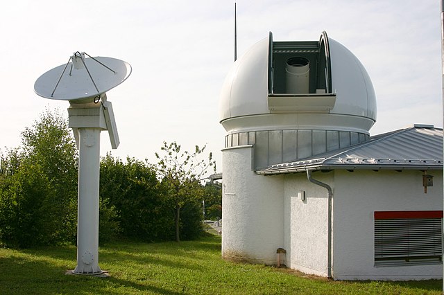
English: Wettzell Laser Ranging System (WLRS), the satellite and lunar laser ranging system of the geodetic observatory in Wettzell, Bavaria. The 75cm telescope in the dome is both used to send the laser pulses and to observe the reflected signal. The small radar dish besides the dome is used to monitor air traffic: The laser is automatically switched off when a aircraft approaches the target position of the laser.
Deutsch: Wettzell Laser Ranging System (WLRS), ein System zur Messung der Entfernung von künstlichen Erdsatelliten und des Mondes am geodätischen Observatorium Wettzell, Bayern. Das 75cm Teleskop in der Kuppel wird sowohl zum Aussenden der Laserimpulse, als auch zum Empfangen des reflektierten Signals verwendet. Die kleine Radarschüssel neben der Kuppel dient der Überwachung des Flugverkehrs: Der Laser wird automatisch abgeschaltet, wenn sich ein Flugzeug der Zielposition des Lasers nähert. |
| Date | |
| Source | Own work |
| Author | H. Raab (User:Vesta) |
| Other versions | See also Image:Geodetic Observatory Wettzell.jpg |
| Camera location | | View this and other nearby images on: OpenStreetMap |
|---|
Licensing
[edit]
I, the copyright holder of this work, hereby publish it under the following licenses:

|
Permission is granted to copy, distribute and/or modify this document under the terms of the GNU Free Documentation License, Version 1.2 or any later version published by the Free Software Foundation; with no Invariant Sections, no Front-Cover Texts, and no Back-Cover Texts. A copy of the license is included in the section entitled GNU Free Documentation License. |
This file is licensed under the Creative Commons Attribution-Share Alike 3.0 Unported license.
- You are free:
- to share – to copy, distribute and transmit the work
- to remix – to adapt the work
- Under the following conditions:
- attribution – You must give appropriate credit, provide a link to the license, and indicate if changes were made. You may do so in any reasonable manner, but not in any way that suggests the licensor endorses you or your use.
- share alike – If you remix, transform, or build upon the material, you must distribute your contributions under the same or compatible license as the original.
You may select the license of your choice.
File history
Click on a date/time to view the file as it appeared at that time.
| Date/Time | Thumbnail | Dimensions | User | Comment | |
|---|---|---|---|---|---|
| current | 23:30, 13 September 2008 | | 1,024 × 682 (165 KB) | Vesta~commonswiki (talk | contribs) | {{Information |Description={{en|1=''Wettzell Laser Ranging System'' (WLRS), the satellite and lunar laser ranging system of the geodetic observatory in Wettzell, Bavaria.}} {{de|1=''Wettzell Laser Ranging System'' (WLRS), ein System zur Messung der Enfern |
You cannot overwrite this file.
File usage on Commons
There are no pages that use this file.
File usage on other wikis
The following other wikis use this file:
- Usage on ca.wikipedia.org
- Usage on cs.wikipedia.org
- Usage on de.wikipedia.org
- Usage on en.wikipedia.org
- Usage on es.wikipedia.org
- Usage on fa.wikipedia.org
- Usage on fr.wikipedia.org
- Usage on hr.wikipedia.org
- Usage on it.wikipedia.org
- Usage on ja.wikipedia.org
- Usage on ka.wikipedia.org
- Usage on lb.wikipedia.org
- Usage on mk.wikipedia.org
- Usage on pl.wikipedia.org
- Usage on pt.wikipedia.org
- Usage on ru.wikipedia.org
- Usage on sr.wikipedia.org
- Usage on zh.wikipedia.org