File:Western part of Île de la Cité, Paris, North view 20140402 1.jpg
Original file (15,345 × 3,868 pixels, file size: 27.01 MB, MIME type: image/jpeg)
Captions
Summary
[edit]DescriptionWestern part of Île de la Cité, Paris, North view 20140402 1.jpg |
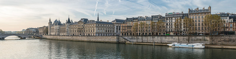
English: The western part of the Île de la Cité in Paris as seen from north (the Pont Neuf). |
Date | |
Source | Own work |
Author | DXR |
Camera location | 48° 51′ 29.78″ N, 2° 20′ 32.46″ E | View this and other nearby images on: OpenStreetMap | 48.858271; 2.342350 |
---|
Panorama by DXR (Category)
The photograph above is a panoramic image which was created by me, Daniel Vorndran, and uploaded here as User:DXR.
Please note:
|
Licensing
[edit]- You are free:
- to share – to copy, distribute and transmit the work
- to remix – to adapt the work
- Under the following conditions:
- attribution – You must give appropriate credit, provide a link to the license, and indicate if changes were made. You may do so in any reasonable manner, but not in any way that suggests the licensor endorses you or your use.
- share alike – If you remix, transform, or build upon the material, you must distribute your contributions under the same or compatible license as the original.
This image has been assessed using the Quality image guidelines and is considered a Quality image.
العربية ∙ جازايرية ∙ беларуская ∙ беларуская (тарашкевіца) ∙ български ∙ বাংলা ∙ català ∙ čeština ∙ Cymraeg ∙ Deutsch ∙ Schweizer Hochdeutsch ∙ Zazaki ∙ Ελληνικά ∙ English ∙ Esperanto ∙ español ∙ eesti ∙ euskara ∙ فارسی ∙ suomi ∙ français ∙ galego ∙ עברית ∙ हिन्दी ∙ hrvatski ∙ magyar ∙ հայերեն ∙ Bahasa Indonesia ∙ italiano ∙ 日本語 ∙ Jawa ∙ ქართული ∙ 한국어 ∙ kurdî ∙ Lëtzebuergesch ∙ lietuvių ∙ македонски ∙ മലയാളം ∙ मराठी ∙ Bahasa Melayu ∙ Nederlands ∙ Norfuk / Pitkern ∙ polski ∙ português ∙ português do Brasil ∙ rumantsch ∙ română ∙ русский ∙ sicilianu ∙ slovenčina ∙ slovenščina ∙ shqip ∙ српски / srpski ∙ svenska ∙ தமிழ் ∙ తెలుగు ∙ ไทย ∙ Tagalog ∙ toki pona ∙ Türkçe ∙ українська ∙ vèneto ∙ Tiếng Việt ∙ 中文 ∙ 中文(简体) ∙ 中文(繁體) ∙ +/− |
File history
Click on a date/time to view the file as it appeared at that time.
Date/Time | Thumbnail | Dimensions | User | Comment | |
---|---|---|---|---|---|
current | 14:35, 25 January 2015 | 15,345 × 3,868 (27.01 MB) | Paris 16 (talk | contribs) | - road at left corner | |
15:33, 18 January 2015 | 15,345 × 3,868 (20.94 MB) | DXR (talk | contribs) | Uploaded with LrMediaWiki 0.2.2 |
You cannot overwrite this file.
File usage on Commons
The following 4 pages use this file:
File usage on other wikis
The following other wikis use this file:
- Usage on fr.wikipedia.org
Metadata
This file contains additional information such as Exif metadata which may have been added by the digital camera, scanner, or software program used to create or digitize it. If the file has been modified from its original state, some details such as the timestamp may not fully reflect those of the original file. The timestamp is only as accurate as the clock in the camera, and it may be completely wrong.
Camera manufacturer | NIKON CORPORATION |
---|---|
Camera model | NIKON D800 |
Author | Daniel Vorndran |
Copyright holder |
|
Date and time of data generation | 08:22, 2 April 2014 |
User comments | -
Projection: Rectilinear (0) FOV: 86 x 30 Ev: 12.61 |
Latitude | 48° 51′ 29.78″ N |
Longitude | 2° 20′ 32.46″ E |
Short title |
|
City shown | Paris |
Width | 15,345 px |
Height | 3,868 px |
Bits per component |
|
Pixel composition | RGB |
Orientation | Normal |
Number of components | 3 |
Horizontal resolution | 240 dpi |
Vertical resolution | 240 dpi |
Software used | Adobe Photoshop CS6 (Macintosh) |
File change date and time | 21:23, 25 January 2015 |
Exif version | 2.3 |
Date and time of digitizing | 08:22, 2 April 2014 |
Color space | sRGB |
GPS tag version | 0.0.2.2 |
Serial number of camera | 6129754 |
Date metadata was last modified | 04:23, 26 January 2015 |
Unique ID of original document | 268B7B22A2C977E4A247E236484316ED |
Province or state shown | Île-de-France |
Country shown | Frankreich |
Sublocation of city shown | Saint-Germain-l'Auxerrois |
IIM version | 4 |
Structured data
Items portrayed in this file
depicts
48°51'29.776"N, 2°20'32.460"E
2 April 2014
image/jpeg
- Files with coordinates missing SDC location of creation (48° N, 2° E)
- CC-BY-SA-4.0
- Quality images
- Quality images missing SDC source of file
- Quality images missing SDC depicts
- Uploaded with LrMediaWiki
- Uploads by User:DXR
- Uploads by User:DXR in Île-de-France
- Uploads by User:DXR in 2014
- Panoramic Images by User:DXR
- Quality Images by User:DXR
- Quality images of cityscapes of Paris
- France photographs taken on 2014-04-02