File:West of Athenry - geograph.org.uk - 1259408.jpg
Jump to navigation
Jump to search
No higher resolution available.
West_of_Athenry_-_geograph.org.uk_-_1259408.jpg (640 × 426 pixels, file size: 184 KB, MIME type: image/jpeg)
Captions
Captions
Add a one-line explanation of what this file represents
Summary
[edit]
| Description |
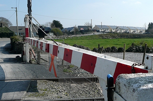
English: West of Athenry In the foreground is a level crossing over the Dublin to Galway railway line about a kilometre west of Athenry station. Under the bridge behind runs the Athenry via Ennis to Limerick railway line closed to passengers in 1976 and to freight in the 1990s. That line is due to reopen in 2010, following a campaign by the "West on Track" group. This road is seeing a lot of heavy traffic at the moment as lorries bring in material for the M6 Dublin to Galway motorway construction. |
| Date | |
| Source | From geograph.org.uk |
| Author | Graham Horn |
| Attribution (required by the license) | Graham Horn / West of Athenry / |
| Camera location | | View this and other nearby images on: OpenStreetMap |
|---|
_heading:180.00&language=en)
| Object location | | View this and other nearby images on: OpenStreetMap |
|---|
_heading:180.00&language=en)
Licensing
[edit]

|
This image was taken from the Geograph project collection. See this photograph's page on the Geograph website for the photographer's contact details. The copyright on this image is owned by Graham Horn and is licensed for reuse under the Creative Commons Attribution-ShareAlike 2.0 license.
|
This file is licensed under the Creative Commons Attribution-Share Alike 2.0 Generic license.
Attribution: Graham Horn
- You are free:
- to share – to copy, distribute and transmit the work
- to remix – to adapt the work
- Under the following conditions:
- attribution – You must give appropriate credit, provide a link to the license, and indicate if changes were made. You may do so in any reasonable manner, but not in any way that suggests the licensor endorses you or your use.
- share alike – If you remix, transform, or build upon the material, you must distribute your contributions under the same or compatible license as the original.
File history
Click on a date/time to view the file as it appeared at that time.
| Date/Time | Thumbnail | Dimensions | User | Comment | |
|---|---|---|---|---|---|
| current | 21:45, 26 February 2011 | | 640 × 426 (184 KB) | GeographBot (talk | contribs) | == {{int:filedesc}} == {{Information |description={{en|1=West of Athenry In the foreground is a level crossing over the Dublin to Galway railway line about a kilometre west of Athenry station. Under the bridge behind runs the Athenry via Ennis to Limeric |
You cannot overwrite this file.
File usage on Commons
There are no pages that use this file.