File:West Mill - Sherborne - geograph.org.uk - 611416.jpg
Jump to navigation
Jump to search
No higher resolution available.
West_Mill_-_Sherborne_-_geograph.org.uk_-_611416.jpg (612 × 429 pixels, file size: 151 KB, MIME type: image/jpeg)
Captions
Captions
Add a one-line explanation of what this file represents
Summary
[edit]
| Description |
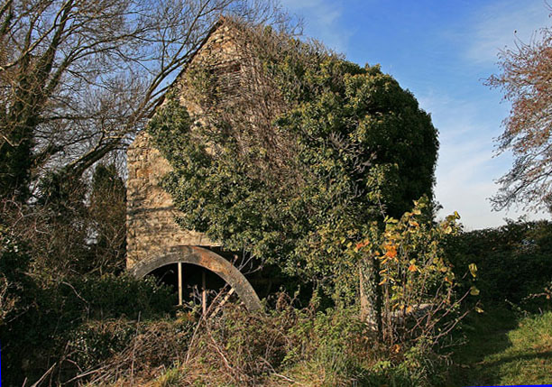
English: West Mill - Sherborne At the end of West Mill Lane near the Civic Amenity Site (Tip), stands this early C18 mill that replaced an even earlier one. This is now the only surviving mill in Sherborne, and is Grade II Listed. Worked commercially until the 1950s, it is currently in danger of disappearing entirely on its east side by encroaching ivy. The mill sits directly on the river Yeo, and after its restoration in 1979 by the boys of Sherborne School, there were grand plans mooted at that time, to return it to use as an exhibition centre. Sadly, like the mill, these plans appear to have been abandoned. |
| Date | |
| Source | From geograph.org.uk |
| Author | Mike Searle |
| Attribution (required by the license) | Mike Searle / West Mill - Sherborne / |
| Camera location | | View this and other nearby images on: OpenStreetMap |
|---|
_heading:270.00&language=en)
| Object location | | View this and other nearby images on: OpenStreetMap |
|---|
_heading:270.00&language=en)
Licensing
[edit]

|
This image was taken from the Geograph project collection. See this photograph's page on the Geograph website for the photographer's contact details. The copyright on this image is owned by Mike Searle and is licensed for reuse under the Creative Commons Attribution-ShareAlike 2.0 license.
|
This file is licensed under the Creative Commons Attribution-Share Alike 2.0 Generic license.
Attribution: Mike Searle
- You are free:
- to share – to copy, distribute and transmit the work
- to remix – to adapt the work
- Under the following conditions:
- attribution – You must give appropriate credit, provide a link to the license, and indicate if changes were made. You may do so in any reasonable manner, but not in any way that suggests the licensor endorses you or your use.
- share alike – If you remix, transform, or build upon the material, you must distribute your contributions under the same or compatible license as the original.
File history
Click on a date/time to view the file as it appeared at that time.
| Date/Time | Thumbnail | Dimensions | User | Comment | |
|---|---|---|---|---|---|
| current | 04:16, 7 February 2011 | | 612 × 429 (151 KB) | GeographBot (talk | contribs) | == {{int:filedesc}} == {{Information |description={{en|1=West Mill - Sherborne At the end of West Mill Lane near the Civic Amenity Site (Tip), stands this early C18 mill that replaced an even earlier one. This is now the only surviving mill in Sherborne, |
You cannot overwrite this file.
File usage on Commons
There are no pages that use this file.