File:West Country map.png
Jump to navigation
Jump to search

Size of this preview: 800 × 560 pixels. Other resolutions: 320 × 224 pixels | 640 × 448 pixels | 1,024 × 717 pixels | 1,280 × 896 pixels | 2,560 × 1,792 pixels | 4,000 × 2,800 pixels.
Original file (4,000 × 2,800 pixels, file size: 1.54 MB, MIME type: image/png)
Captions
Captions
Add a one-line explanation of what this file represents

|
This file was moved to Wikimedia Commons from wts.oldwikivoyage using a bot script. All source information is still present. It requires review. Additionally, there may be errors in any or all of the information fields; information on this file should not be considered reliable and the file should not be used until it has been reviewed and any needed corrections have been made. Once the review has been completed, this template should be removed. For details about this file, see below. Check now! |
Summary
[edit]
| Description |
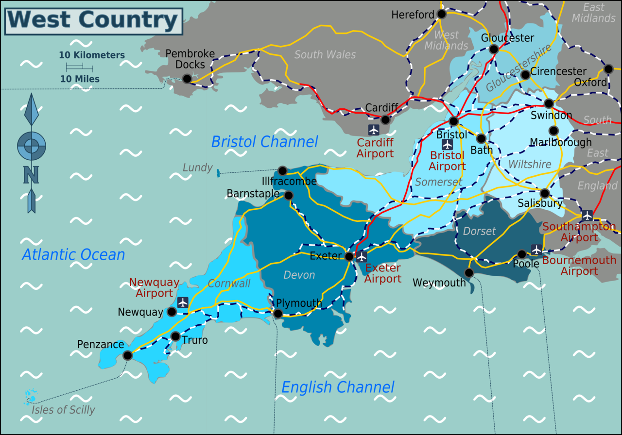
Map of the West Country showing counties and major cities Source: Image:West_Country_map.svg & :Image:UK map.svg
|
| Date | 30 November 2006 (original upload date) |
| Source | :Image:UK map.svg |
| Author | User: (WT-shared) Paul. at wts wikivoyage |
| Location | West Country |
Licensing
[edit]
This file is licensed under the Creative Commons Attribution-Share Alike 1.0 Generic license.
- You are free:
- to share – to copy, distribute and transmit the work
- to remix – to adapt the work
- Under the following conditions:
- attribution – You must give appropriate credit, provide a link to the license, and indicate if changes were made. You may do so in any reasonable manner, but not in any way that suggests the licensor endorses you or your use.
- share alike – If you alter, transform, or build upon this work, you must distribute the resulting work under the same license as the original.
Original upload log
[edit]
| This file was imported from Wikivoyage WTS. |
The original description page was here. All following user names refer to wts.wikivoyage-old.
- 2006-11-30 19:46 (WT-shared) Paul.[dead link] 1102×769 (23392 bytes) Map of the West Country showing counties and major cities Source: [[:Image:UK map.svg]] {{location|West_Country}} (Import from wikitravel.org/shared)
- 2006-11-30 23:47 (WT-shared) Paul.[dead link] 1102×769 (23726 bytes) (Import from wikitravel.org/shared)
- 2012-04-09 18:44 (WT-shared) Travelpleb[dead link] 4709×3295 (1940225 bytes) {{Imagecredit|credit=Travelpleb|captureDate=10th April 2012|location=West_Country|source=Image:West_Country_map.svg|caption=West Country|des (Import from wikitravel.org/shared)
- 2012-04-09 18:52 (WT-shared) Travelpleb[dead link] 4709×3295 (1940225 bytes) (Import from wikitravel.org/shared)
- 2012-04-09 18:57 (WT-shared) Travelpleb[dead link] 4709×3294 (1950953 bytes) (Import from wikitravel.org/shared)
- 2012-04-09 19:02 (WT-shared) Travelpleb[dead link] 5908×4188 (107127 bytes) (Import from wikitravel.org/shared)
- 2012-04-09 19:04 (WT-shared) Travelpleb[dead link] 2955×3294 (988102 bytes) (Import from wikitravel.org/shared)
- 2012-04-09 19:08 (WT-shared) Travelpleb[dead link] 4706×3294 (1869036 bytes) (Import from wikitravel.org/shared)
- 2012-04-09 19:11 (WT-shared) Travelpleb[dead link] 4000×2800 (1613412 bytes) (Import from wikitravel.org/shared)
File history
Click on a date/time to view the file as it appeared at that time.
| Date/Time | Thumbnail | Dimensions | User | Comment | |
|---|---|---|---|---|---|
| current | 03:50, 18 December 2012 | | 4,000 × 2,800 (1.54 MB) | OgreBot (talk | contribs) | (BOT): Reverting to most recent version before archival |
| 03:50, 18 December 2012 |  | 4,706 × 3,294 (1.78 MB) | OgreBot (talk | contribs) | (BOT): Uploading old version of file from wts.wikivoyage; originally uploaded on 2012-04-09 19:08:45 by (WT-shared) Travelpleb | |
| 03:50, 18 December 2012 |  | 2,955 × 3,294 (965 KB) | OgreBot (talk | contribs) | (BOT): Uploading old version of file from wts.wikivoyage; originally uploaded on 2012-04-09 19:04:32 by (WT-shared) Travelpleb | |
| 03:50, 18 December 2012 |  | 5,908 × 4,188 (105 KB) | OgreBot (talk | contribs) | (BOT): Uploading old version of file from wts.wikivoyage; originally uploaded on 2012-04-09 19:02:50 by (WT-shared) Travelpleb | |
| 03:50, 18 December 2012 |  | 4,709 × 3,294 (1.86 MB) | OgreBot (talk | contribs) | (BOT): Uploading old version of file from wts.wikivoyage; originally uploaded on 2012-04-09 18:57:56 by (WT-shared) Travelpleb | |
| 03:50, 18 December 2012 |  | 4,709 × 3,295 (1.85 MB) | OgreBot (talk | contribs) | (BOT): Uploading old version of file from wts.wikivoyage; originally uploaded on 2012-04-09 18:44:07 by (WT-shared) Travelpleb | |
| 03:50, 18 December 2012 |  | 1,102 × 769 (23 KB) | OgreBot (talk | contribs) | (BOT): Uploading old version of file from wts.wikivoyage; originally uploaded on 2006-11-30 23:47:46 by (WT-shared) Paul. | |
| 03:50, 18 December 2012 |  | 1,102 × 769 (23 KB) | OgreBot (talk | contribs) | (BOT): Uploading old version of file from wts.wikivoyage; originally uploaded on 2006-11-30 19:46:57 by (WT-shared) Paul. | |
| 03:23, 18 November 2012 |  | 4,000 × 2,800 (1.54 MB) | MGA73bot2 (talk | contribs) | {{BotMoveToCommons|wts.oldwikivoyage|year={{subst:CURRENTYEAR}}|month={{subst:CURRENTMONTHNAME}}|day={{subst:CURRENTDAY}}}} == {{int:filedesc}} == {{Information |description=Map of the West Country showing counties and major cities Source: [[:wts:Imag... |
You cannot overwrite this file.
File usage on Commons
There are no pages that use this file.
File usage on other wikis
The following other wikis use this file:
- Usage on en.wikivoyage.org
- Usage on fa.wikivoyage.org
- Usage on he.wikivoyage.org
- Usage on it.wikivoyage.org
- Usage on nl.wikivoyage.org
- Usage on pl.wikivoyage.org