File:West Coast MODIS via EOSDIS 20180801.png
Jump to navigation
Jump to search
Size of this preview: 356 × 599 pixels. Other resolutions: 142 × 240 pixels | 589 × 991 pixels.
Original file (589 × 991 pixels, file size: 1.34 MB, MIME type: image/png)
Captions
Captions
Add a one-line explanation of what this file represents
Summary
[edit]
| Description |
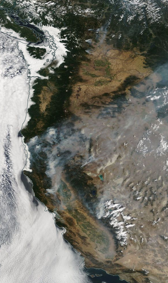
English: Color satellite image of United States West Coast on August 1, 2018. Low clouds on the coast and in Western Washington are visible. Elsewhere the ground is quite visible, with the exception of smoke from some forest fires in the Cascades and great firest in the Sierras. |
| Date | |
| Source | NASA Earth Science Data and Information System (ESDIS) Worldview viewer https://worldview.earthdata.nasa.gov/ |
| Author | NASA (Terra satellite MODIS sensor) |
| Other versions |
File:Washington MODIS via EOSDIS 20180801.png  |
Licensing
[edit]
| This file is in the public domain in the United States because it was solely created by NASA. NASA copyright policy states that "NASA material is not protected by copyright unless noted". (See Template:PD-USGov, NASA copyright policy page or JPL Image Use Policy.) | ||
 |
Warnings:
|
File history
Click on a date/time to view the file as it appeared at that time.
| Date/Time | Thumbnail | Dimensions | User | Comment | |
|---|---|---|---|---|---|
| current | 23:27, 6 August 2018 | | 589 × 991 (1.34 MB) | Bri (talk | contribs) | User created page with UploadWizard |
You cannot overwrite this file.
File usage on Commons
The following page uses this file:
File usage on other wikis
The following other wikis use this file:
- Usage on ca.wikipedia.org
- Usage on de.wikipedia.org
- Usage on en.wikipedia.org
- Usage on fa.wikipedia.org
- Usage on fi.wikipedia.org
- Usage on fr.wikipedia.org
- Usage on he.wikipedia.org
- Usage on ko.wikipedia.org
- Usage on pt.wikipedia.org
- Usage on simple.wikipedia.org
- Usage on vi.wikipedia.org
Metadata
Categories:
- Satellite pictures of Washington (state)
- August 2018 in Washington (state)
- 2018 wildfires in Washington (state)
- Photos of wildfires by the Terra (satellite) MODIS
- Photos of the United States by the Terra (satellite) MODIS
- Satellite pictures of the 2018 California wildfires
- Satellite pictures of Oregon
- Satellite pictures of California
- August 2018 in California