File:Welden in 1620.jpg
Jump to navigation
Jump to search

Size of this preview: 778 × 600 pixels. Other resolutions: 312 × 240 pixels | 623 × 480 pixels | 997 × 768 pixels | 1,203 × 927 pixels.
Original file (1,203 × 927 pixels, file size: 301 KB, MIME type: image/jpeg)
Captions
Captions
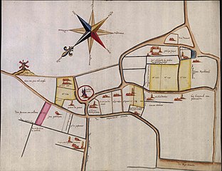
Kaart van het centrum van het dorp Welden omstreeks 1620. De eigenaars van de percelen zijn aangeduid op deze kaart. Bemerk de ongewone orientatie van de map. Duidelijk is de Oleyemolen te zien op deze kaart. (plaats huidige Kouterstraat)
Summary
[edit]
| Description |
English: Map of the center of the village of Welden around 1620. The owners of the plots are indicated on this map. Note the unusual orientation of the map. The Oleyemolen is clearly visible on this map. (place of current Kouterstraat) |
| Date | circa 1620 |
| Source | https://www.facebook.com/photo/?fbid=10219830238015848&set=gm.2271312479848926 |
| Author | Diederik De Clercq |
| Permission (Reusing this file) |
Map drawn in the year 1620. Copyrights are expired since a long time. |
Licensing
[edit]
|
This work is in the public domain in its country of origin and other countries and areas where the copyright term is the author's life plus 70 years or fewer. | |
| This file has been identified as being free of known restrictions under copyright law, including all related and neighboring rights. | |
File history
Click on a date/time to view the file as it appeared at that time.
| Date/Time | Thumbnail | Dimensions | User | Comment | |
|---|---|---|---|---|---|
| current | 21:27, 21 August 2022 | | 1,203 × 927 (301 KB) | Piet De Pauw (talk | contribs) | Uploaded a work by Diederik De Clercq from https://www.facebook.com/photo/?fbid=10219830238015848&set=gm.2271312479848926 with UploadWizard |
You cannot overwrite this file.
File usage on Commons
There are no pages that use this file.
File usage on other wikis
The following other wikis use this file:
- Usage on nl.wikipedia.org