File:Weihetalbrücke-1993-08-03.jpg
Jump to navigation
Jump to search

Size of this preview: 800 × 509 pixels. Other resolutions: 320 × 204 pixels | 640 × 407 pixels | 1,024 × 652 pixels | 1,280 × 815 pixels | 2,560 × 1,630 pixels | 3,280 × 2,088 pixels.
Original file (3,280 × 2,088 pixels, file size: 1.43 MB, MIME type: image/jpeg)
Captions
Captions
Add a one-line explanation of what this file represents
Summary
[edit]
| Description |
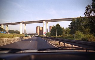
Deutsch: Weihetalbrücke Richelsdorf, Autobahn A 4, bei Gerstungen, Thüringen, im Bau 1993, fotografiert auf der Umfahrungsstrecke - von Dia eingescannt
English: Weihetalbridge Richelsdorf, Autobahn A 4, near Gerstungen, Thuringia, Germany, under construction 1993 - scanned from color slide |
| Date | |
| Source | Own work |
| Author | Hubert Berberich (HubiB) |
| Permission (Reusing this file) |
public domain |
| Camera location | | View this and other nearby images on: OpenStreetMap |
|---|
Licensing
[edit]
| I, the copyright holder of this work, release this work into the public domain. This applies worldwide. In some countries this may not be legally possible; if so: I grant anyone the right to use this work for any purpose, without any conditions, unless such conditions are required by law. |
File history
Click on a date/time to view the file as it appeared at that time.
| Date/Time | Thumbnail | Dimensions | User | Comment | |
|---|---|---|---|---|---|
| current | 17:17, 31 March 2011 | | 3,280 × 2,088 (1.43 MB) | HubiB (talk | contribs) | == {{int:filedesc}} == {{Information |Description = {{de|Weihetalbrücke Richelsdorf, Autobahn A 4, bei Gerstungen, Thüringen, im Bau 1993, fotografiert auf der Umfahrungsstrecke - von Dia eingescannt}} {{en|Weihetalbridge Richelsdorf, Autobahn A 4, near |
You cannot overwrite this file.
File usage on Commons
There are no pages that use this file.
File usage on other wikis
The following other wikis use this file:
- Usage on de.wikipedia.org