File:Waverley Line 2015.png
Jump to navigation
Jump to search

Size of this preview: 567 × 599 pixels. Other resolutions: 227 × 240 pixels | 454 × 480 pixels | 726 × 768 pixels | 968 × 1,024 pixels | 2,234 × 2,362 pixels.
Original file (2,234 × 2,362 pixels, file size: 3.04 MB, MIME type: image/png)
Captions
Captions
Add a one-line explanation of what this file represents
Summary
[edit]| Description |
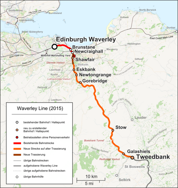
English: Map of the en:Waverley Line in Scotland, as it will be opened in September 2015. |
| Date | |
| Source |
|
| Author | |
| Permission (Reusing this file) |
Map data (c) OpenStreetMap (and) contributors, CC-BY-SA |
| Other versions |
|

Licensing
[edit]
This file is licensed under the Creative Commons Attribution-Share Alike 2.0 Generic license.
- You are free:
- to share – to copy, distribute and transmit the work
- to remix – to adapt the work
- Under the following conditions:
- attribution – You must give appropriate credit, provide a link to the license, and indicate if changes were made. You may do so in any reasonable manner, but not in any way that suggests the licensor endorses you or your use.
- share alike – If you remix, transform, or build upon the material, you must distribute your contributions under the same or compatible license as the original.
File history
Click on a date/time to view the file as it appeared at that time.
| Date/Time | Thumbnail | Dimensions | User | Comment | |
|---|---|---|---|---|---|
| current | 14:01, 15 September 2018 | | 2,234 × 2,362 (3.04 MB) | Pechristener (talk | contribs) | Fife Circle Line instead of Five Circle Line |
| 17:04, 2 May 2015 |  | 2,234 × 2,362 (3.04 MB) | Pechristener (talk | contribs) | Bessere Unterscheidung derübringen Bahnstrecken zwischen in "Betrieb" und "nicht mehr in Betrieb" gemäß Anregung aus Disk der Artikelkandidatur | |
| 21:14, 23 March 2015 |  | 2,234 × 2,362 (3.04 MB) | Pechristener (talk | contribs) | Karte verkleinert / aufgehobene Linie grau | |
| 19:33, 9 March 2015 |  | 2,234 × 5,059 (5.76 MB) | Pechristener (talk | contribs) | Update gemäss Review Verkehr: Lockerbie statt Lockerbee / St Boswells statt St. Boswells / ganze Waverly Line dargestellt und den nicht wieder in Betrieb genommenen Rest als solches deklariert | |
| 03:02, 3 January 2015 |  | 2,234 × 3,436 (3.98 MB) | Pechristener (talk | contribs) | Update gemäss KW | |
| 13:52, 1 January 2015 |  | 2,234 × 3,436 (3.07 MB) | Pechristener (talk | contribs) | {{Information |Description={{en|Map of the en:Waverley Line in Scotland, as it will be opened in September 2015.}} |Source=*{{own}}, map was created using [http://www.openstreetmap.org/ Open Street Map] |Date=2015-01-01 |Author=*[[User:Pechristene... |
You cannot overwrite this file.
File usage on Commons
The following 10 pages use this file:
- User:Liesel/Rail transport/2015 January 1-10
- User:Mattbuck/Railways/2015 January 1-10
- User:Mattbuck/Railways/2015 March 1-10
- User:Mattbuck/Railways/2015 March 21-31
- User:Mattbuck/Railways/2015 May 1-10
- User:Mattbuck/Railways/2018 September
- File:Waverley Line 1969.png
- File:Waverley Line 2015 en.png
- File:Waverly Line 2015.png (file redirect)
File usage on other wikis
The following other wikis use this file:
- Usage on de.wikipedia.org