File:Wath Road Junction geograph-2178423.jpg
Jump to navigation
Jump to search

Size of this preview: 800 × 497 pixels. Other resolutions: 320 × 199 pixels | 640 × 398 pixels | 1,024 × 636 pixels.
Original file (1,024 × 636 pixels, file size: 292 KB, MIME type: image/jpeg)
Captions
Captions
Add a one-line explanation of what this file represents
Summary
[edit]
| Description |
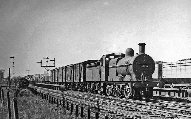
English: Parallel Up freight trains on the Midland main lines at Wath Road Junction. View northward, to the signalbox - just visible, then left towards Cudworth, Normanton and Leeds, right towards Pontefract and York. Here ex- MIdland 3F 0-6-0 No. 43714 is bringing up a Class J goods on the Up Fast line while a train of high-capacity coke wagons is running parallel on the Up Slow. Underneath ran the ex-Great Central main line between Mexborough and Wath Yard |
| Date | Taken on 17 June 1957 |
| Source | From geograph.org.uk |
| Author | Ben Brooksbank |
| Permission (Reusing this file) |
Creative Commons Attribution Share-alike license 2.0 |
| Camera location | | View this and other nearby images on: OpenStreetMap |
|---|
Licensing
[edit]

|
This image was taken from the Geograph project collection. See this photograph's page on the Geograph website for the photographer's contact details. The copyright on this image is owned by Ben Brooksbank and is licensed for reuse under the Creative Commons Attribution-ShareAlike 2.0 license.
|
This file is licensed under the Creative Commons Attribution-Share Alike 2.0 Generic license.
Attribution: Ben Brooksbank
- You are free:
- to share – to copy, distribute and transmit the work
- to remix – to adapt the work
- Under the following conditions:
- attribution – You must give appropriate credit, provide a link to the license, and indicate if changes were made. You may do so in any reasonable manner, but not in any way that suggests the licensor endorses you or your use.
- share alike – If you remix, transform, or build upon the material, you must distribute your contributions under the same or compatible license as the original.
File history
Click on a date/time to view the file as it appeared at that time.
| Date/Time | Thumbnail | Dimensions | User | Comment | |
|---|---|---|---|---|---|
| current | 14:10, 29 November 2010 | | 1,024 × 636 (292 KB) | Chevin (talk | contribs) | == {{int:filedesc}} == {{Information |Description={{en|1=Parallel Up freight trains on the Midland main lines at Wath Road Junction View northward, to the signalbox - just visible, then left towards Cudworth, Normanton and Leeds, right towards Pontefract |
You cannot overwrite this file.
File usage on Commons
There are no pages that use this file.
File usage on other wikis
The following other wikis use this file:
- Usage on en.wikipedia.org