File:Waterland Close - geograph.org.uk - 481341.jpg
Jump to navigation
Jump to search
No higher resolution available.
Waterland_Close_-_geograph.org.uk_-_481341.jpg (640 × 443 pixels, file size: 98 KB, MIME type: image/jpeg)
Captions
Captions
Add a one-line explanation of what this file represents
Summary
[edit]
| Description |
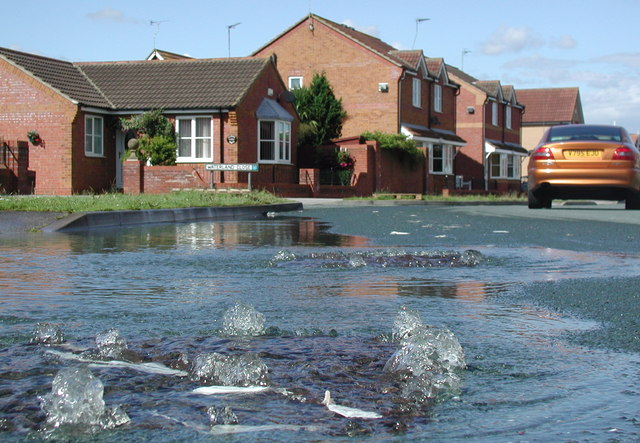
English: Waterland Close, Hedon, East Riding of Yorkshire, England. Water gushing from the manhole covers at the junction of Cleeve Road and Waterland Close, south of Hedon. The nearby Burstwick Drain has proved unable to cope with the huge volume of water being channelled south and west towards the River Humber after recent heavy rains and the residents of this housing estate have been supplied with sandbags in case the situation gets any worse. The drain and other smaller ones overflowed onto the surrounding farmland creating a shallow lake with very few patches of dry land in between, stretching for almost three kilometres from the greenhouses near Hall Bridge in Burstwick to the Villa Lane junction on the A1033 between Hedon and Thorngumbald. When this photograph was taken the water in some places had already receded by a foot or more, thanks largely to a concerted effort by the fire brigade. |
| Date | |
| Source | From geograph.org.uk |
| Author | Paul Glazzard |
| Permission (Reusing this file) |
Creative Commons Attribution Share-alike license 2.0 |
| Attribution (required by the license) | Paul Glazzard / Waterland Close / |
| Camera location | | View this and other nearby images on: OpenStreetMap |
|---|
_heading:22.00&language=en)
| Object location | | View this and other nearby images on: OpenStreetMap |
|---|
_heading:22.00&language=en)
Licensing
[edit]

|
This image was taken from the Geograph project collection. See this photograph's page on the Geograph website for the photographer's contact details. The copyright on this image is owned by Paul Glazzard and is licensed for reuse under the Creative Commons Attribution-ShareAlike 2.0 license.
|
This file is licensed under the Creative Commons Attribution-Share Alike 2.0 Generic license.
Attribution: Paul Glazzard
- You are free:
- to share – to copy, distribute and transmit the work
- to remix – to adapt the work
- Under the following conditions:
- attribution – You must give appropriate credit, provide a link to the license, and indicate if changes were made. You may do so in any reasonable manner, but not in any way that suggests the licensor endorses you or your use.
- share alike – If you remix, transform, or build upon the material, you must distribute your contributions under the same or compatible license as the original.
File history
Click on a date/time to view the file as it appeared at that time.
| Date/Time | Thumbnail | Dimensions | User | Comment | |
|---|---|---|---|---|---|
| current | 03:16, 5 February 2011 | | 640 × 443 (98 KB) | GeographBot (talk | contribs) | == {{int:filedesc}} == {{Information |description={{en|1=Waterland Close Water gushing from the manhole covers at the junction of Cleeve Road and Waterland Close, south of Hedon. The nearby Burstwick Drain has proved unable to cope with the huge volume of |
You cannot overwrite this file.
File usage on Commons
There are no pages that use this file.