File:Wasserschloss Reinharz.jpg
Original file (2,592 × 3,888 pixels, file size: 6.07 MB, MIME type: image/jpeg)
Captions
Summary
[edit]Camera location | 51° 41′ 55.76″ N, 12° 40′ 33.3″ E | View this and other nearby images on: OpenStreetMap
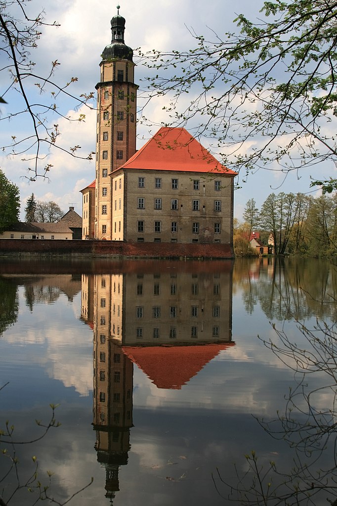
 | 51.698822; 12.675917 |
---|
DescriptionWasserschloss Reinharz.jpg |
Deutsch: Barockes Wasserschloss in Reinharz (Stadt Bad Schmiedeberg)
erbaut 1690 - 1701 von Heinrich Löser
English: Baroque castle with moat in Reinharz (town of Bad Schmiedeberg), Germany, built 1690-1701 by Heinrich Loeser
| ||
Address InfoField |
|
||
Date | Taken on 26 April 2008 | ||
Source | Own work | ||
Author | Kerstin Rehmann (Urheber) |
Licensing
[edit]- You are free:
- to share – to copy, distribute and transmit the work
- to remix – to adapt the work
- Under the following conditions:
- attribution – You must give appropriate credit, provide a link to the license, and indicate if changes were made. You may do so in any reasonable manner, but not in any way that suggests the licensor endorses you or your use.
- share alike – If you remix, transform, or build upon the material, you must distribute your contributions under the same or compatible license as the original.
This image was uploaded as part of Wiki Loves Monuments 2011.
Afrikaans ∙ Alemannisch ∙ العربية ∙ جازايرية ∙ azərbaycanca ∙ Bikol Central ∙ беларуская ∙ беларуская (тарашкевіца) ∙ български ∙ বাংলা ∙ brezhoneg ∙ bosanski ∙ català ∙ čeština ∙ Cymraeg ∙ dansk ∙ Deutsch ∙ Zazaki ∙ Ελληνικά ∙ English ∙ Esperanto ∙ español ∙ eesti ∙ euskara ∙ فارسی ∙ suomi ∙ français ∙ Frysk ∙ Gaeilge ∙ galego ∙ עברית ∙ हिन्दी ∙ hrvatski ∙ magyar ∙ հայերեն ∙ Bahasa Indonesia ∙ Ido ∙ italiano ∙ 日本語 ∙ ქართული ∙ 한국어 ∙ кыргызча ∙ Lëtzebuergesch ∙ latviešu ∙ Malagasy ∙ македонски ∙ മലയാളം ∙ Bahasa Melayu ∙ Malti ∙ norsk bokmål ∙ नेपाली ∙ Nederlands ∙ norsk nynorsk ∙ norsk ∙ polski ∙ português ∙ português do Brasil ∙ română ∙ русский ∙ sicilianu ∙ davvisámegiella ∙ slovenčina ∙ slovenščina ∙ shqip ∙ српски / srpski ∙ svenska ∙ ไทย ∙ Tagalog ∙ Türkçe ∙ українська ∙ اردو ∙ oʻzbekcha / ўзбекча ∙ Yorùbá ∙ 中文 ∙ 中文(中国大陆) ∙ 中文(简体) ∙ 中文(繁體) ∙ 中文(香港) ∙ 中文(臺灣) ∙ +/− |
File history
Click on a date/time to view the file as it appeared at that time.
Date/Time | Thumbnail | Dimensions | User | Comment | |
---|---|---|---|---|---|
current | 18:35, 5 September 2011 | 2,592 × 3,888 (6.07 MB) | Kerstin Rehmann (talk | contribs) |
You cannot overwrite this file.
File usage on Commons
There are no pages that use this file.
File usage on other wikis
The following other wikis use this file:
Metadata
This file contains additional information such as Exif metadata which may have been added by the digital camera, scanner, or software program used to create or digitize it. If the file has been modified from its original state, some details such as the timestamp may not fully reflect those of the original file. The timestamp is only as accurate as the clock in the camera, and it may be completely wrong.
Camera manufacturer | Canon |
---|---|
Camera model | Canon EOS 400D DIGITAL |
Exposure time | 1/160 sec (0.00625) |
F-number | f/8 |
ISO speed rating | 100 |
Date and time of data generation | 13:46, 26 April 2008 |
Lens focal length | 28 mm |
Pixel composition | RGB |
Orientation | Normal |
Horizontal resolution | 350 dpi |
Vertical resolution | 350 dpi |
Software used | Digital Photo Professional |
File change date and time | 13:46, 26 April 2008 |
Y and C positioning | Centered |
Custom image processing | Normal process |
Exposure mode | Auto exposure |
White balance | Auto white balance |
Scene capture type | Standard |
Exposure Program | Landscape mode (for landscape photos with the background in focus) |
Exif version | 2.21 |
Date and time of digitizing | 13:46, 26 April 2008 |
APEX shutter speed | 7.3219299316406 |
APEX aperture | 6 |
APEX exposure bias | 0 |
Flash | Flash did not fire, compulsory flash suppression |
Color space | sRGB |
Focal plane X resolution | 4,453.6082474227 |
Focal plane Y resolution | 4,433.2953249715 |
Focal plane resolution unit | inches |
Structured data
Items portrayed in this file
depicts
26 April 2008
51°41'55.759"N, 12°40'33.301"E
51°41'55.75999"N, 12°40'33.30001"E
0.00625 second
28 millimetre
100
image/jpeg
- Files with coordinates missing SDC location of creation
- Buildings with addresses
- Saxony-Anhalt photographs taken on 2008-04-26
- CC-BY-SA-3.0
- Self-published work
- Images from Wiki Loves Monuments 2011
- Images from Wiki Loves Monuments 2011 in Germany
- Images from Wiki Loves Monuments missing SDC depicts
- Images from Wiki Loves Monuments missing SDC location of creation
- Images from Wiki Loves Monuments missing SDC creator
- Images from Wiki Loves Monuments 2011, DE-ST