File:Washwood Heath 1 railway geograph-2163479.jpg
Jump to navigation
Jump to search
Size of this preview: 800 × 437 pixels. Other resolutions: 320 × 175 pixels | 640 × 349 pixels | 1,024 × 559 pixels.
Original file (1,024 × 559 pixels, file size: 292 KB, MIME type: image/jpeg)
Captions
Captions
Add a one-line explanation of what this file represents
Summary
[edit]
| Description |
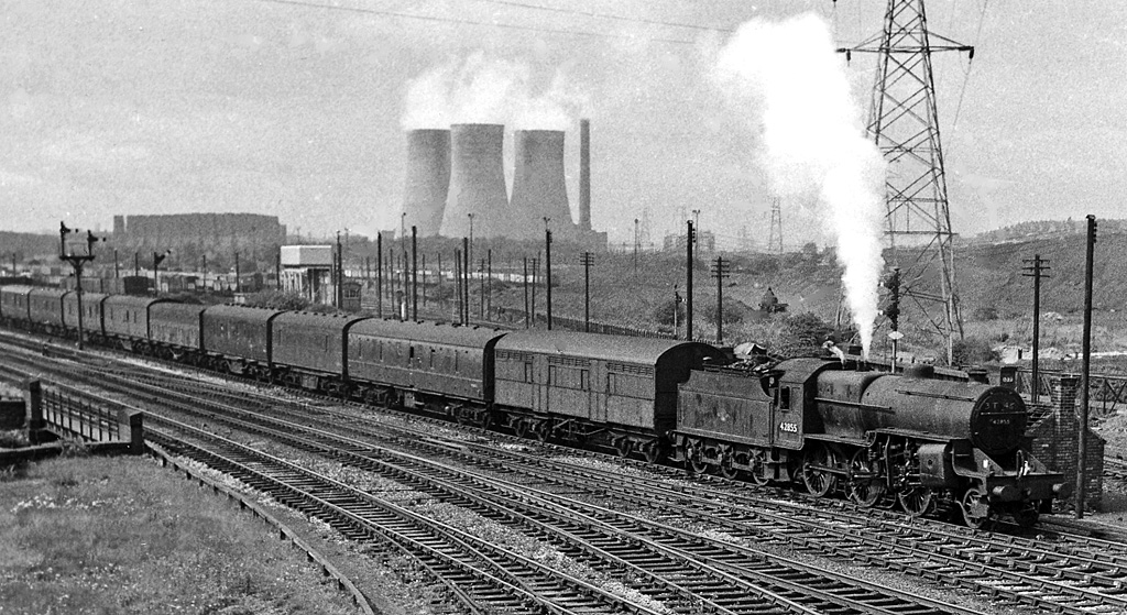
English: A view NW from Bromford Lane bridge at the east end of the Washwood Heath Yards. An Up Parcels train (headed by Hughes/Fowler 5P4F 2-6-0 No. 42855) on the ex-Midland Birmingham - Derby etc. main line is approaching Bromford Bridge Station. Beyond the railway is the far eastern end (Up side) of the vast Washwood Heath Yards and further over is Nechells Power Station. Nowadays - over 48 years later - this scene is dominated by the great M6 Motorway: see for example SP1189 : Washwood Heath Viaduct and SP1189 : Washwood Heath railway sidings. |
| Date | |
| Source | From geograph.org.uk |
| Author | Ben Brooksbank |
| Permission (Reusing this file) |
Creative Commons Attribution Share-alike license 2.0 |
| Attribution (required by the license) | Ben Brooksbank / A view NW from Bromford Lane bridge at the east end of the Washwood Heath Yards / |
| Camera location | | View this and other nearby images on: OpenStreetMap |
|---|
Licensing
[edit]

|
This image was taken from the Geograph project collection. See this photograph's page on the Geograph website for the photographer's contact details. The copyright on this image is owned by Ben Brooksbank and is licensed for reuse under the Creative Commons Attribution-ShareAlike 2.0 license.
|
This file is licensed under the Creative Commons Attribution-Share Alike 2.0 Generic license.
Attribution: Ben Brooksbank
- You are free:
- to share – to copy, distribute and transmit the work
- to remix – to adapt the work
- Under the following conditions:
- attribution – You must give appropriate credit, provide a link to the license, and indicate if changes were made. You may do so in any reasonable manner, but not in any way that suggests the licensor endorses you or your use.
- share alike – If you remix, transform, or build upon the material, you must distribute your contributions under the same or compatible license as the original.
File history
Click on a date/time to view the file as it appeared at that time.
| Date/Time | Thumbnail | Dimensions | User | Comment | |
|---|---|---|---|---|---|
| current | 14:04, 20 November 2010 | | 1,024 × 559 (292 KB) | Chevin (talk | contribs) | == {{int:filedesc}} == {{Information |Description={{en|1=A view NW from Bromford Lane bridge at the east end of the Washwood Heath Yards An Up Parcels train (headed by Hughes/Fowler 5P4F 2-6-0 No. 42855) on the ex-Midland Birmingham - Derby etc. main line |
You cannot overwrite this file.
File usage on Commons
There are no pages that use this file.
File usage on other wikis
The following other wikis use this file:
- Usage on en.wikipedia.org