File:Warszawski Węzeł Kolejowy - schemat.svg
Jump to navigation
Jump to search

Size of this PNG preview of this SVG file: 601 × 600 pixels. Other resolutions: 240 × 240 pixels | 481 × 480 pixels | 769 × 768 pixels | 1,026 × 1,024 pixels | 2,052 × 2,048 pixels | 1,065 × 1,063 pixels.
Original file (SVG file, nominally 1,065 × 1,063 pixels, file size: 100 KB)
Captions
Captions
Add a one-line explanation of what this file represents
Summary
[edit]
| Description |
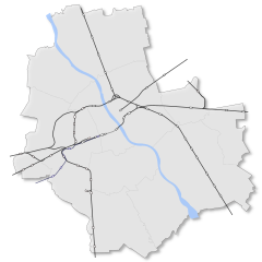
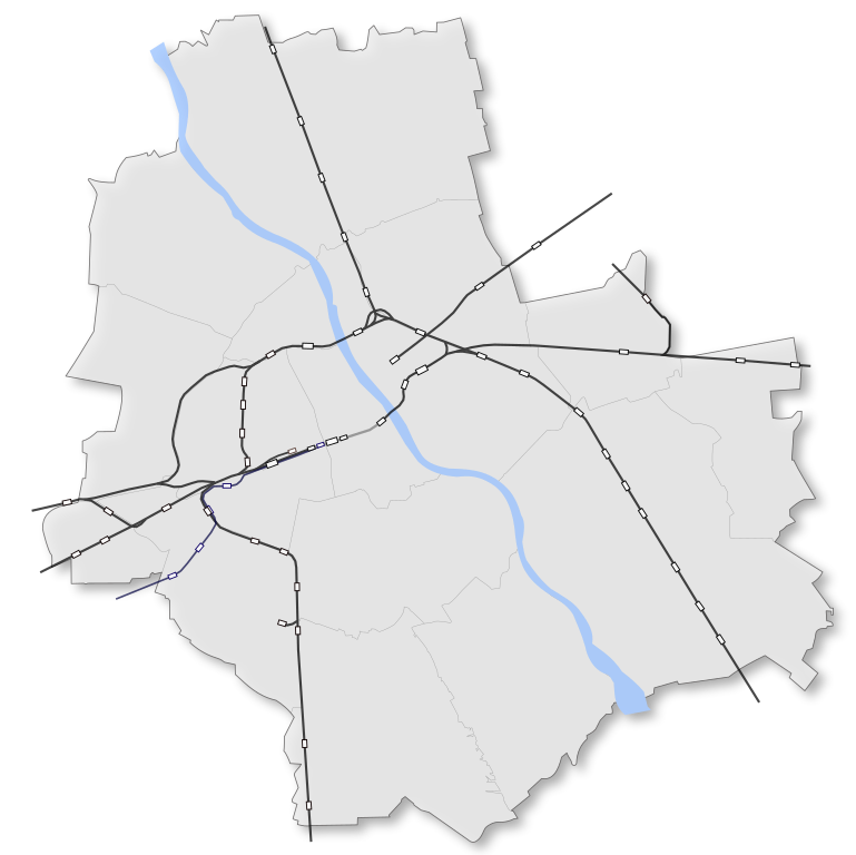
English: Warsaw railway junction map Polski: Schemat warszawskiego węzła kolejowego |
| Date | |
| Source | File:W-wa wola.svg |
| Author | Malarz pl |
Licensing
[edit]

|
Permission is granted to copy, distribute and/or modify this document under the terms of the GNU Free Documentation License, Version 1.2 or any later version published by the Free Software Foundation; with no Invariant Sections, no Front-Cover Texts, and no Back-Cover Texts. A copy of the license is included in the section entitled GNU Free Documentation License. |
| This file is licensed under the Creative Commons Attribution-Share Alike 3.0 Unported license. | ||
| ||
| This licensing tag was added to this file as part of the GFDL licensing update. |
This file is licensed under the Creative Commons Attribution-Share Alike 2.5 Generic, 2.0 Generic and 1.0 Generic license.
- You are free:
- to share – to copy, distribute and transmit the work
- to remix – to adapt the work
- Under the following conditions:
- attribution – You must give appropriate credit, provide a link to the license, and indicate if changes were made. You may do so in any reasonable manner, but not in any way that suggests the licensor endorses you or your use.
- share alike – If you remix, transform, or build upon the material, you must distribute your contributions under the same or compatible license as the original.
File history
Click on a date/time to view the file as it appeared at that time.
| Date/Time | Thumbnail | Dimensions | User | Comment | |
|---|---|---|---|---|---|
| current | 20:49, 8 January 2024 | | 1,065 × 1,063 (100 KB) | Szczureq (talk | contribs) | added Warszawa Targówek |
| 20:45, 8 January 2024 |  | 1,065 × 1,063 (100 KB) | Szczureq (talk | contribs) | added Warszawa Grochów | |
| 10:08, 6 April 2020 |  | 1,065 × 1,063 (100 KB) | Szczureq (talk | contribs) | added Warszawa Powązki | |
| 17:05, 27 November 2018 |  | 1,065 × 1,063 (104 KB) | Szczureq (talk | contribs) | added Ursus-Niedźwiadek and Mokry Ług | |
| 12:40, 27 November 2018 |  | 1,065 × 1,063 (103 KB) | Szczureq (talk | contribs) | added Warszawa Koło | |
| 19:36, 19 June 2014 |  | 1,065 × 1,063 (103 KB) | Kubek15 (talk | contribs) | Dodanie stacji W-wa Aleje Jerozolimskie, W-Wa Żwirki i Wigury oraz W-wa Zacisze Wilno, bocznicy kolejowej na lotnisko i linii kolejowej Rembertów-Zielonka. | |
| 09:42, 31 May 2011 |  | 1,065 × 1,063 (99 KB) | Malarz pl (talk | contribs) | scale as in File:Warszawa outline with districts v4.svg | |
| 09:29, 31 May 2011 |  | 1,037 × 1,082 (98 KB) | Malarz pl (talk | contribs) |
You cannot overwrite this file.
File usage on Commons
The following 6 pages use this file:
- User:Chumwa/OgreBot/Public transport information/2020 April 1-10
- User:Chumwa/OgreBot/Public transport information/2024 January 1-10
- User:Chumwa/OgreBot/Transport Maps/2020 April 1-10
- User:Chumwa/OgreBot/Transport Maps/2024 January 1-10
- User:Cybularny/Warsaw/2018 November 16-30
- User:Cybularny/Warsaw/2020 April 1-15
File usage on other wikis
The following other wikis use this file:
- Usage on cs.wikipedia.org
- Usage on en.wikipedia.org
- Usage on pl.wikipedia.org
- Dworzec Centralny im. Stanisława Moniuszki
- Dworzec Wiedeński w Warszawie
- Warszawa Zachodnia
- Warszawa Wileńska
- Warszawa Gdańska
- Warszawa Wschodnia
- Szablon:Stacja kolejowa infobox
- Szablon:Transport kolejowy w Warszawie
- Kolej średnicowa w Warszawie
- Warszawa Olszynka Grochowska
- Warszawa Gocławek
- Warszawa Anin
- Warszawa Międzylesie
- Warszawa Radość
- Warszawa Miedzeszyn
- Warszawa Falenica
- Warszawa Toruńska
- Warszawa Żerań
- Warszawa Płudy
- Warszawa Choszczówka
- Warszawa Wola (przystanek kolejowy)
- Warszawa Młynów
- Warszawa Zoo
- Warszawa Ochota (przystanek kolejowy)
- Warszawa Powiśle
- Warszawa Stadion
- Warszawa Gołąbki
- Warszawa Ursus Północny
- Warszawa Rakowiec
- Warszawa Służewiec
- Warszawa Okęcie
- Warszawa Dawidy
- Warszawa Jeziorki
- Warszawa Wola Grzybowska
- Warszawa Śródmieście WKD
- Warszawa Zachodnia WKD
- Warszawa Reduta Ordona
- Warszawa Raków
- Warszawa Salomea
- Dworzec Główny w Warszawie
- Warszawa Główna
- Kolej obwodowa w Warszawie
- Wikiprojekt:Warszawa
- Warszawa Zacisze
- Targówek (stacja kolejowa)
- Warszawa Południowa
- Warszawa Włochy EKD
- Wikipedysta:Nessah/brudnopis
View more global usage of this file.