File:Walton-on-the-Naze, All Saints Church - geograph.org.uk - 1475668.jpg
Jump to navigation
Jump to search
No higher resolution available.
Walton-on-the-Naze,_All_Saints_Church_-_geograph.org.uk_-_1475668.jpg (640 × 480 pixels, file size: 60 KB, MIME type: image/jpeg)
Captions
Captions
Add a one-line explanation of what this file represents
Summary
[edit]
| Description |
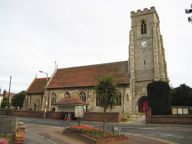
English: Walton-on-the-Naze: All Saints Church Walton's original church eventually succumbed to the erosion of the cliffs and fell into the sea around 1798, so the current church, set well inland, is not particularly old. The first church on this site was one built of brick with construction starting in 1804, and a tower being added later. However the growth of Walton as a holiday resort and the construction of the railway in Victorian times led to a rapid growth in population. As a consequence a new church built in stone was planned and built progressively as the old brick one was dismantled.
The chancel to the left and the nave in the centre were built between 1874 and 1882, and the tower on the right added from start to finish during 1896. The Church's website is here http://allsaintswalton.org.uk/ |
| Date | |
| Source | From geograph.org.uk |
| Author | Nigel Cox |
| Attribution (required by the license) | Nigel Cox / Walton-on-the-Naze: All Saints Church / |
| Camera location | | View this and other nearby images on: OpenStreetMap |
|---|
_heading:135.00&language=en)
| Object location | | View this and other nearby images on: OpenStreetMap |
|---|
_heading:135.00&language=en)
Licensing
[edit]

|
This image was taken from the Geograph project collection. See this photograph's page on the Geograph website for the photographer's contact details. The copyright on this image is owned by Nigel Cox and is licensed for reuse under the Creative Commons Attribution-ShareAlike 2.0 license.
|
This file is licensed under the Creative Commons Attribution-Share Alike 2.0 Generic license.
Attribution: Nigel Cox
- You are free:
- to share – to copy, distribute and transmit the work
- to remix – to adapt the work
- Under the following conditions:
- attribution – You must give appropriate credit, provide a link to the license, and indicate if changes were made. You may do so in any reasonable manner, but not in any way that suggests the licensor endorses you or your use.
- share alike – If you remix, transform, or build upon the material, you must distribute your contributions under the same or compatible license as the original.
File history
Click on a date/time to view the file as it appeared at that time.
| Date/Time | Thumbnail | Dimensions | User | Comment | |
|---|---|---|---|---|---|
| current | 13:26, 2 March 2011 | | 640 × 480 (60 KB) | GeographBot (talk | contribs) | == {{int:filedesc}} == {{Information |description={{en|1=Walton-on-the-Naze: All Saints Church Walton's original church eventually succumbed to the erosion of the cliffs and fell into the sea around 1798, so the current church, set well inland, is not par |
You cannot overwrite this file.
File usage on Commons
The following page uses this file:
File usage on other wikis
The following other wikis use this file:
- Usage on www.wikidata.org