File:Walker Lake Panorama.jpg
From Wikimedia Commons, the free media repository
Jump to navigation
Jump to search
![File:Walker Lake Panorama.jpg](https://upload.wikimedia.org/wikipedia/commons/thumb/3/3e/Walker_Lake_Panorama.jpg/800px-Walker_Lake_Panorama.jpg?20220629234309)
Size of this preview: 800 × 129 pixels. Other resolutions: 320 × 52 pixels | 640 × 103 pixels | 1,024 × 165 pixels | 6,071 × 979 pixels.
Original file (6,071 × 979 pixels, file size: 4.3 MB, MIME type: image/jpeg)
File information
Structured data
Captions
Captions
Add a one-line explanation of what this file represents
Summary
[edit]DescriptionWalker Lake Panorama.jpg |
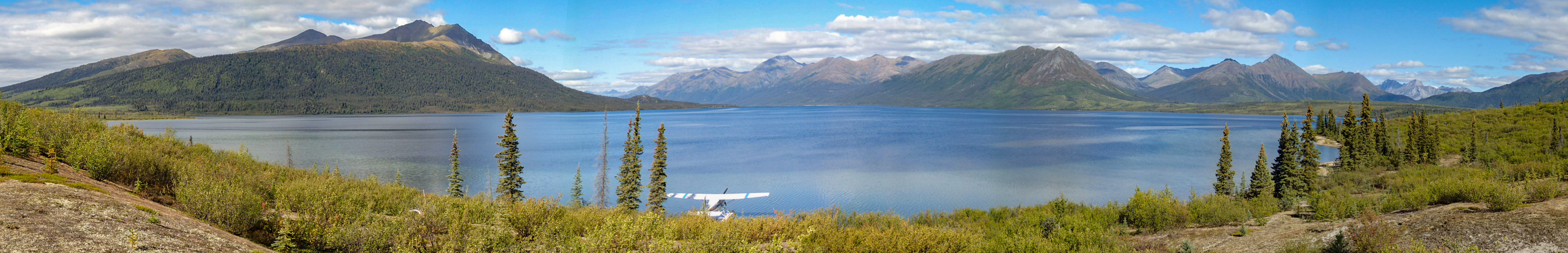
English: Walker Lake panorama with the Brooks Range across the lake in summer. |
Date | |
Source | https://home.nps.gov/gaar/learn/nature/index.htm |
Author | NPS |
Camera location | 67° 03′ 35.84″ N, 154° 18′ 03.94″ W ![]() ![]() | View this and other nearby images on: OpenStreetMap | ![]() |
---|
Licensing
[edit]Public domainPublic domainfalsefalse |
![]() |
This image or media file contains material based on a work of a National Park Service employee, created as part of that person's official duties. As a work of the U.S. federal government, such work is in the public domain in the United States. See the NPS website and NPS copyright policy for more information. | ![]() |
File history
Click on a date/time to view the file as it appeared at that time.
Date/Time | Thumbnail | Dimensions | User | Comment | |
---|---|---|---|---|---|
current | 23:43, 29 June 2022 | ![]() | 6,071 × 979 (4.3 MB) | Timk70 (talk | contribs) | Uploaded a work by NPS from https://home.nps.gov/gaar/learn/nature/index.htm with UploadWizard |
You cannot overwrite this file.
File usage on Commons
The following page uses this file:
Metadata
This file contains additional information such as Exif metadata which may have been added by the digital camera, scanner, or software program used to create or digitize it. If the file has been modified from its original state, some details such as the timestamp may not fully reflect those of the original file. The timestamp is only as accurate as the clock in the camera, and it may be completely wrong.
Image title |
|
---|---|
Camera manufacturer | OLYMPUS IMAGING CORP. |
Camera model | TG-2 |
Exposure time | 1/640 sec (0.0015625) |
F-number | f/4.5 |
ISO speed rating | 100 |
Date and time of data generation | 07:15, 22 August 2013 |
Lens focal length | 8.99 mm |
Latitude | 67° 3′ 35.84″ N |
Longitude | 154° 18′ 3.94″ W |
Width | 3,968 px |
Height | 1,048 px |
Bits per component |
|
Pixel composition | RGB |
Orientation | Normal |
Number of components | 3 |
Horizontal resolution | 160 dpi |
Vertical resolution | 160 dpi |
Software used | Adobe Photoshop CC (Windows) |
File change date and time | 12:24, 23 November 2018 |
Y and C positioning | Co-sited |
Exposure Program | Creative program (biased toward depth of field) |
Exif version | 2.3 |
Date and time of digitizing | 07:15, 22 August 2013 |
Meaning of each component |
|
APEX shutter speed | 9.321928 |
APEX aperture | 4.33985 |
APEX exposure bias | 0.7 |
Maximum land aperture | 2 APEX (f/2) |
Metering mode | Pattern |
Light source | Unknown |
Flash | Flash did not fire, compulsory flash suppression |
Supported Flashpix version | 1 |
Color space | sRGB |
File source | Digital still camera |
Custom image processing | Normal process |
Exposure mode | Manual exposure |
White balance | Auto white balance |
Digital zoom ratio | 1 |
Focal length in 35 mm film | 49 mm |
Scene capture type | Standard |
Scene control | None |
Contrast | Normal |
Saturation | Normal |
Sharpness | Normal |
Receiver status | Measurement in progress |
Reference for direction of image | Magnetic direction |
Direction of image | 316 |
Name of GPS area | |
GPS tag version | 0.0.3.2 |
Serial number of camera | BGX514580 |
Date metadata was last modified | 04:24, 23 November 2018 |
Unique ID of original document | B143BBCA0D5528EDF24259E9571E8E11 |