File:Waidhofen an der Ybbs - Amstettner Hütte.JPG
Jump to navigation
Jump to search

Size of this preview: 800 × 546 pixels. Other resolutions: 320 × 218 pixels | 640 × 436 pixels | 1,024 × 698 pixels | 1,280 × 873 pixels | 2,560 × 1,746 pixels | 3,578 × 2,440 pixels.
Original file (3,578 × 2,440 pixels, file size: 9 MB, MIME type: image/jpeg)
Captions
Captions
Add a one-line explanation of what this file represents
Summary
[edit]
| Description |
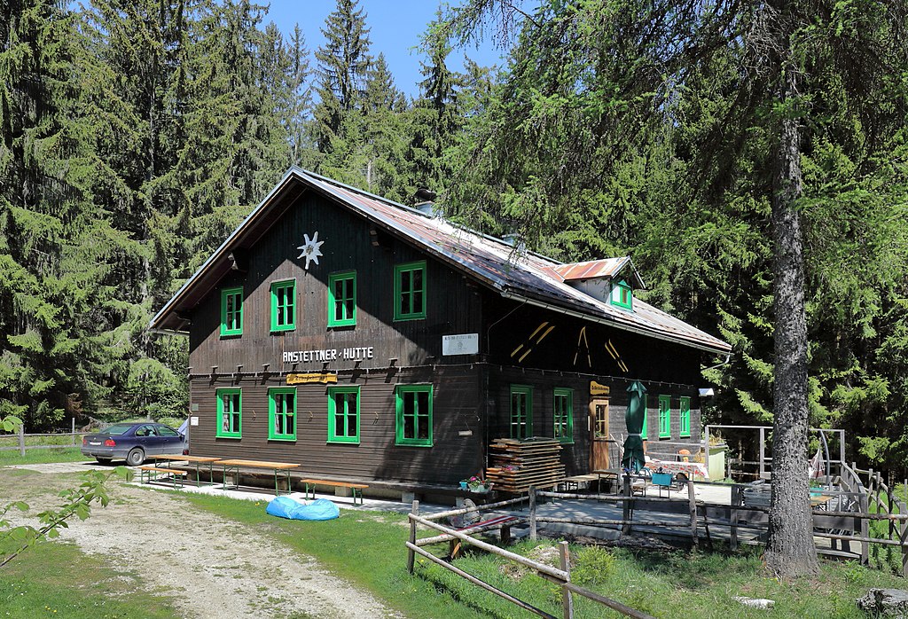
Deutsch: Südansicht der Amstettner Hütte auf der Forsteralm bei Gaflenz in den Ybbstaler Alpen. Die Hütte befindet sich unmittelbar an der Landesgrenze von Oberösterreich und Niederösterreich auf dem Gemeindegebiet der niederösterreichischen Stadtgemeinde Waidhofen an der Ybbs. Sie wurde von der Sektion Amstetten des Österreichischen Alpenvereins ab 1957 errichtet und Weihnachten 1959 als „Neue Amstettner Hütte“ eröffnet. Die „Alte Amstettner Hütte“, ein Ausbau einer alten Almhütte auf der Forsteralm und auf der oberösterreichischen Seite (eröffnet 1932), wurde anschließend bis auf weiteres geschlossen. |
| Date | |
| Source | Own work |
| Author | C.Stadler/Bwag |
| Permission (Reusing this file) |
Deutsch: Hallo, du darfst meine Fotos kostenlos nutzen, aber nenne mich bitte als Fotograf, beispielsweise „Foto: C.Stadler/Bwag“ oder © C.Stadler/Bwag; CC-BY-SA-4.0. Auf mehr Angaben bestehe ich nicht - im Gegensatz zu manch anderen, die die Vorgaben der unten angeführten Lizenzierung auf Punkt und Beistrich einfordern. English: Feel free to use my photos, but please mention me as the author like © C.Stadler/Bwag or © C.Stadler/Bwag; CC-BY-SA-4.0 (that's good enough) and if you want send me a message: bwag@gmx.net. |
| Object location | | View this and other nearby images on: OpenStreetMap |
|---|
| Camera location | | View this and other nearby images on: OpenStreetMap |
|---|
Licensing
[edit]
I, the copyright holder of this work, hereby publish it under the following license:
This file is licensed under the Creative Commons Attribution-Share Alike 4.0 International license.
- You are free:
- to share – to copy, distribute and transmit the work
- to remix – to adapt the work
- Under the following conditions:
- attribution – You must give appropriate credit, provide a link to the license, and indicate if changes were made. You may do so in any reasonable manner, but not in any way that suggests the licensor endorses you or your use.
- share alike – If you remix, transform, or build upon the material, you must distribute your contributions under the same or compatible license as the original.
File history
Click on a date/time to view the file as it appeared at that time.
| Date/Time | Thumbnail | Dimensions | User | Comment | |
|---|---|---|---|---|---|
| current | 21:16, 13 May 2020 | | 3,578 × 2,440 (9 MB) | Bwag (talk | contribs) | {{Information |Description= {{de|1=Südansicht der Amstettner Hütte auf der Forsteralm bei Gaflenz in den Ybbstaler Alpen.<br/>Die Hütte befindet sich unmittelbar an der Landesgrenze von Oberösterreich und Niederösterreich auf dem Gemeindegebiet der niederösterreichischen Stadtgemeinde Waidhofen an der Ybbs. Sie wurde von der Sektion Amstetten des [[:de:Österreichischer Alpenverein|Österreichischen... |
You cannot overwrite this file.
File usage on Commons
The following page uses this file:
File usage on other wikis
The following other wikis use this file:
- Usage on de.wikipedia.org
- Liste der Hütten des Österreichischen Alpenvereins
- Wikipedia:WikiProjekt Österreich/WD/Waidhofen an der Ybbs
- Amstettner Hütte
- Wikipedia:Projekt WikiAlpenforum (WAF)/Artikelwunsch Alpenverein/Schutzhütten nach Gebirgszug
- Wikipedia:Projekt WikiAlpenforum (WAF)/Artikelwunsch Alpenverein/Schutzhütten nach Verwaltungseinheit
- Usage on de.wikivoyage.org
- Usage on www.wikidata.org