File:Wadamisaki Line-Aerial photography.png
Jump to navigation
Jump to search

Size of this preview: 800 × 439 pixels. Other resolutions: 320 × 175 pixels | 640 × 351 pixels | 1,024 × 561 pixels | 1,280 × 702 pixels | 3,241 × 1,777 pixels.
Original file (3,241 × 1,777 pixels, file size: 9.24 MB, MIME type: image/png)
Captions
Captions
Add a one-line explanation of what this file represents
Summary
[edit]
| Description |
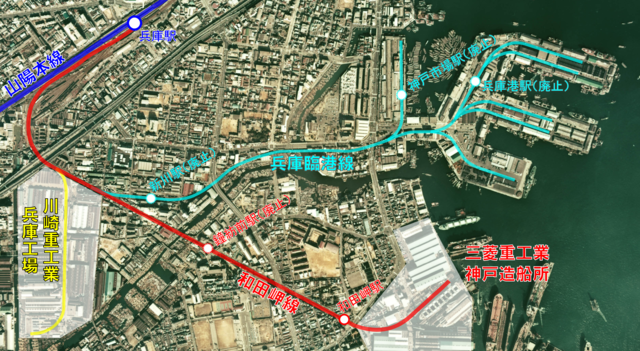
English: Japanese National Railways San'yō Main Line Wadamisaki Branch (Wadamisaki Line) and Hyōgo Rinkō Branch. Japan Fiscal Year 1974. 日本語: 日本国有鉄道 山陽本線支線(和田岬線・兵庫臨港線)。昭和49年度。 |
| Date | |
| Source | 国土交通省 / Ministry of Land, Infrastructure, Transport and Tourism (Japan) |
| Author | ButuCC |
Licensing
[edit]

|
The copyright holder of this file, the Ministry of Land, Infrastructure, Transport and Tourism of Japan, allows anyone to use it for any purpose, provided that the copyright holder is properly attributed. Redistribution, derivative work, commercial use, and all other use is permitted. |
Attribution:
Copyright © National Land Image Information (Color Aerial Photographs), Ministry of Land, Infrastructure, Transport and Tourism
|
 |
This image is copyrighted by the Ministry of Land, Infrastructure, Transport and Tourism of Japan. For terms of use, see the stipulation to use of National Land Information (in Japanese) and message from MLIT (in Japanese and English). When you display this image on an article, include the following phrase in the description: "Made based on National Land Image Information (Color Aerial Photographs), Ministry of Land, Infrastructure, Transport and Tourism".
|
File history
Click on a date/time to view the file as it appeared at that time.
| Date/Time | Thumbnail | Dimensions | User | Comment | |
|---|---|---|---|---|---|
| current | 15:05, 28 September 2013 | | 3,241 × 1,777 (9.24 MB) | ButuCC (talk | contribs) | User created page with UploadWizard |
You cannot overwrite this file.
File usage on Commons
The following page uses this file:
File usage on other wikis
The following other wikis use this file:
- Usage on ja.wikipedia.org