File:Votic language map.png
Jump to navigation
Jump to search
Size of this preview: 646 × 600 pixels. Other resolutions: 259 × 240 pixels | 517 × 480 pixels | 827 × 768 pixels | 1,103 × 1,024 pixels | 2,206 × 2,048 pixels | 2,991 × 2,777 pixels.
Original file (2,991 × 2,777 pixels, file size: 204 KB, MIME type: image/png)
Captions
Captions
Add a one-line explanation of what this file represents

|
This map image could be re-created using vector graphics as an SVG file. This has several advantages; see Commons:Media for cleanup for more information. If an SVG form of this image is available, please upload it and afterwards replace this template with
{{vector version available|new image name}}.
It is recommended to name the SVG file “Votic language map.svg”—then the template Vector version available (or Vva) does not need the new image name parameter. |
Summary
[edit]
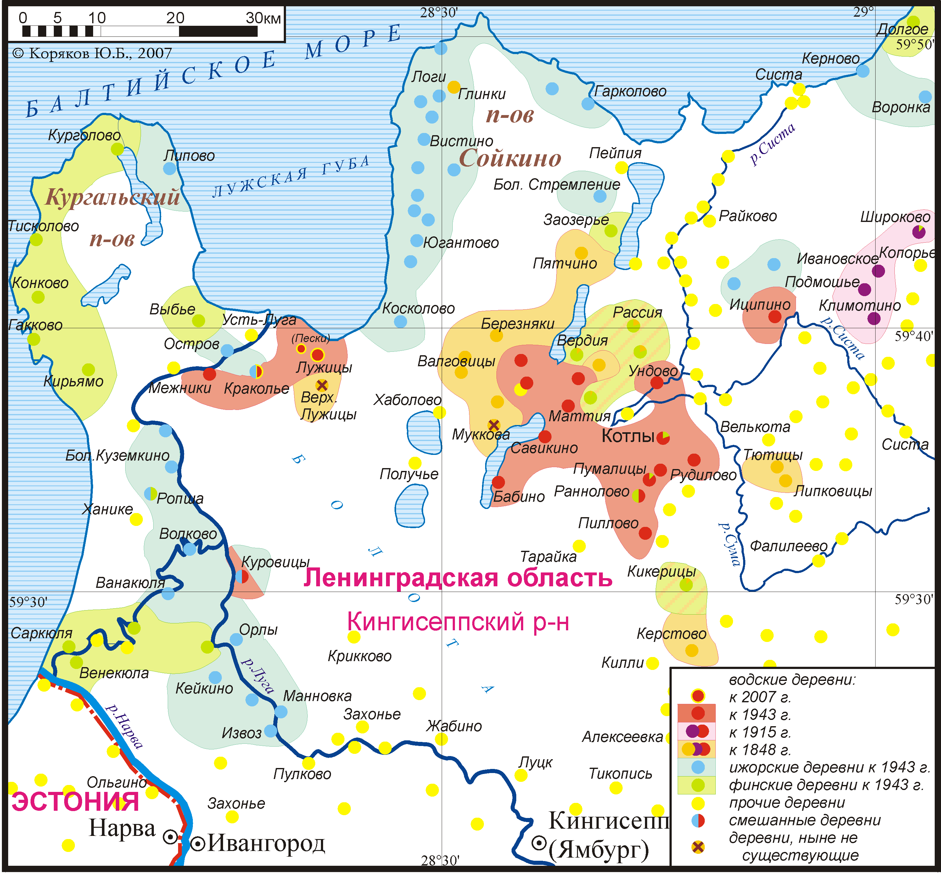
Map of the Votic language and adjacent Finnish and Izhora villages 1848-2007 (in Russian).
Карта водского языка и соседних финских и ижорских деревень, 1848-2007 гг.
| Description |
Нохчийн: Ингрийн меттиг Россе чохь.
English: Finnic settlements in Western Ingria throughout the 20th century. A map of Votic and neighbouring Ingrian-Finnish and Izhorian villages 1848-2007.
Latviešu: Votu apdzīvotais areāls (krievu val.).
Русский: Этнографическая карта поселений води, ижоры и финнов на западе Ленинградской области. Карта водских, финских и ижорских деревень, 1848—2007 гг. Карта водского языка и соседних финских и ижорских деревень, 1848—2007 гг. Расселения ижор на Сойкинском полуострове в XIX—XX веках.
Українська: Етнографічна мапа розселення фінів, іжорців і водь на заході Ленінградської області. |
| Date | |
| Source | |
| Author | Koryakov Yuri |
Licensing
[edit]
I, the copyright holder of this work, hereby publish it under the following license:
This file is licensed under the Creative Commons Attribution-Share Alike 2.5 Generic license.
- You are free:
- to share – to copy, distribute and transmit the work
- to remix – to adapt the work
- Under the following conditions:
- attribution – You must give appropriate credit, provide a link to the license, and indicate if changes were made. You may do so in any reasonable manner, but not in any way that suggests the licensor endorses you or your use.
- share alike – If you remix, transform, or build upon the material, you must distribute your contributions under the same or compatible license as the original.
File history
Click on a date/time to view the file as it appeared at that time.
| Date/Time | Thumbnail | Dimensions | User | Comment | |
|---|---|---|---|---|---|
| current | 09:41, 6 March 2007 | | 2,991 × 2,777 (204 KB) | Koryakov Yuri (talk | contribs) | Map of the Votic language and adjacent Finnish and Izhora villages 1848-2007 (in Russian). |
You cannot overwrite this file.
File usage on Commons
There are no pages that use this file.
File usage on other wikis
The following other wikis use this file:
- Usage on af.wikipedia.org
- Usage on an.wikipedia.org
- Usage on az.wikipedia.org
- Usage on ba.wikipedia.org
- Usage on be-tarask.wikipedia.org
- Usage on be.wikipedia.org
- Usage on ca.wikipedia.org
- Usage on ce.wikipedia.org
- Usage on cv.wikipedia.org
- Usage on da.wikipedia.org
- Usage on da.wikibooks.org
- Usage on de.wikipedia.org
- Usage on en.wikipedia.org
- Usage on eo.wikipedia.org
- Usage on et.wikipedia.org
- Usage on fi.wikipedia.org
- Usage on fi.wikiversity.org
- Usage on frr.wikipedia.org
- Usage on fr.wikipedia.org
- Usage on it.wikipedia.org
- Usage on ja.wikipedia.org
- Usage on kk.wikipedia.org
- Usage on kv.wikipedia.org
- Usage on lv.wikipedia.org
- Usage on myv.wikipedia.org
View more global usage of this file.