File:Von Nikopolis bis Golubac.png
Jump to navigation
Jump to search

Size of this preview: 800 × 423 pixels. Other resolutions: 320 × 169 pixels | 640 × 338 pixels | 1,314 × 694 pixels.
Original file (1,314 × 694 pixels, file size: 730 KB, MIME type: image/png)
Captions
Captions
Add a one-line explanation of what this file represents
Summary
[edit]
| Description |
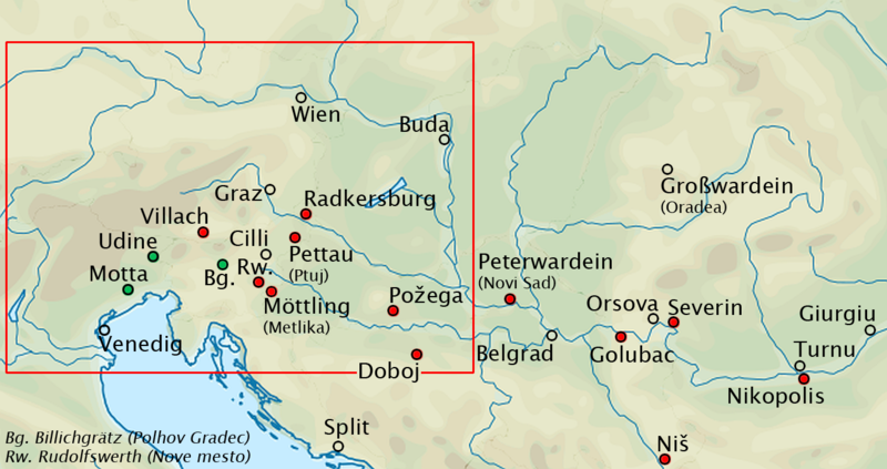
English: Danube and Drava river region with landmarks and locations of real and legendary battles during Ottoman and Hungarian campaigns between 1396 (Nikopolis) and 1428 (Golubac) - For see red rectangle, see detail map File:Styria 1418.png |
| Date | |
| Source | based on File:Europe laea topography.svg |
| Author | Roxanna |
Licensing
[edit]
I, the copyright holder of this work, hereby publish it under the following licenses:

|
Permission is granted to copy, distribute and/or modify this document under the terms of the GNU Free Documentation License, Version 1.2 or any later version published by the Free Software Foundation; with no Invariant Sections, no Front-Cover Texts, and no Back-Cover Texts. A copy of the license is included in the section entitled GNU Free Documentation License. |
This file is licensed under the Creative Commons Attribution-Share Alike 4.0 International license.
- You are free:
- to share – to copy, distribute and transmit the work
- to remix – to adapt the work
- Under the following conditions:
- attribution – You must give appropriate credit, provide a link to the license, and indicate if changes were made. You may do so in any reasonable manner, but not in any way that suggests the licensor endorses you or your use.
- share alike – If you remix, transform, or build upon the material, you must distribute your contributions under the same or compatible license as the original.
You may select the license of your choice.
File history
Click on a date/time to view the file as it appeared at that time.
| Date/Time | Thumbnail | Dimensions | User | Comment | |
|---|---|---|---|---|---|
| current | 21:59, 4 May 2022 | | 1,314 × 694 (730 KB) | Roxanna (talk | contribs) | description positions |
| 10:31, 30 April 2022 |  | 1,314 × 694 (730 KB) | Roxanna (talk | contribs) | red for battles against Ottomans, green for battles against Hungarians | |
| 09:33, 30 April 2022 |  | 1,314 × 694 (726 KB) | Roxanna (talk | contribs) | +Billichgrätz, Möttling | |
| 21:12, 29 April 2022 |  | 1,314 × 694 (716 KB) | Roxanna (talk | contribs) | {{Information |Description={{en|1=Danube and Drava river region with landmarks and locations of real and legendary battles against Ottoman expansion between 1396 (Nikopolis) and 1428 (Golubac) - For see red rectangle, see detail map File:Styria 1418.png}} |Source=based on File:Europe laea topography.svg |Date=2022-04-29 |Author=Roxanna |Permission= |other_versions= }} Category:Topographic maps of the Pannonian Basin Category:Danube Basin |
You cannot overwrite this file.
File usage on Commons
There are no pages that use this file.
File usage on other wikis
The following other wikis use this file:
- Usage on de.wikipedia.org