File:Vingtaine de Longueville.jpg
Jump to navigation
Jump to search

Size of this preview: 800 × 500 pixels. Other resolutions: 320 × 200 pixels | 640 × 400 pixels | 1,024 × 640 pixels | 1,463 × 915 pixels.
Original file (1,463 × 915 pixels, file size: 341 KB, MIME type: image/jpeg)
Captions
Captions
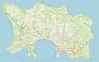
Map of Jersey showing the boundaries of the Vingtaine de Longueville
Summary
[edit]
| Description |
English: Administrative boundary within the parish of Grouville, Jersey |
|||
| Date | ||||
| Source | openstreetmap.org | |||
| Creator |
Aleksandar Matejevic OpenStreetMap contributors |
|||
| Permission (Reusing this file) |
OpenStreetMap data is available under the Open Database License (details). Standard style map tiles are licensed as ODbL Produced Works.
|
|||
| Georeferencing | If inappropriate please set warp_status = skip to hide. |
| Camera location | | View this and other nearby images on: OpenStreetMap |
|---|
Licensing
[edit]
This file is licensed under the Creative Commons Attribution-Share Alike 2.5 Generic license.
- You are free:
- to share – to copy, distribute and transmit the work
- to remix – to adapt the work
- Under the following conditions:
- attribution – You must give appropriate credit, provide a link to the license, and indicate if changes were made. You may do so in any reasonable manner, but not in any way that suggests the licensor endorses you or your use.
- share alike – If you remix, transform, or build upon the material, you must distribute your contributions under the same or compatible license as the original.
File history
Click on a date/time to view the file as it appeared at that time.
| Date/Time | Thumbnail | Dimensions | User | Comment | |
|---|---|---|---|---|---|
| current | 16:29, 23 November 2022 | | 1,463 × 915 (341 KB) | Curb Safe Charmer (talk | contribs) | Uploaded a work by Aleksandar Matejevic from OpenStreetMap with UploadWizard |
You cannot overwrite this file.
File usage on Commons
There are no pages that use this file.
File usage on other wikis
The following other wikis use this file:
- Usage on en.wikipedia.org