File:View of Samshvilde Canyon.jpg
Original file (1,600 × 900 pixels, file size: 726 KB, MIME type: image/jpeg)
Captions
Summary
[edit]DescriptionView of Samshvilde Canyon.jpg |
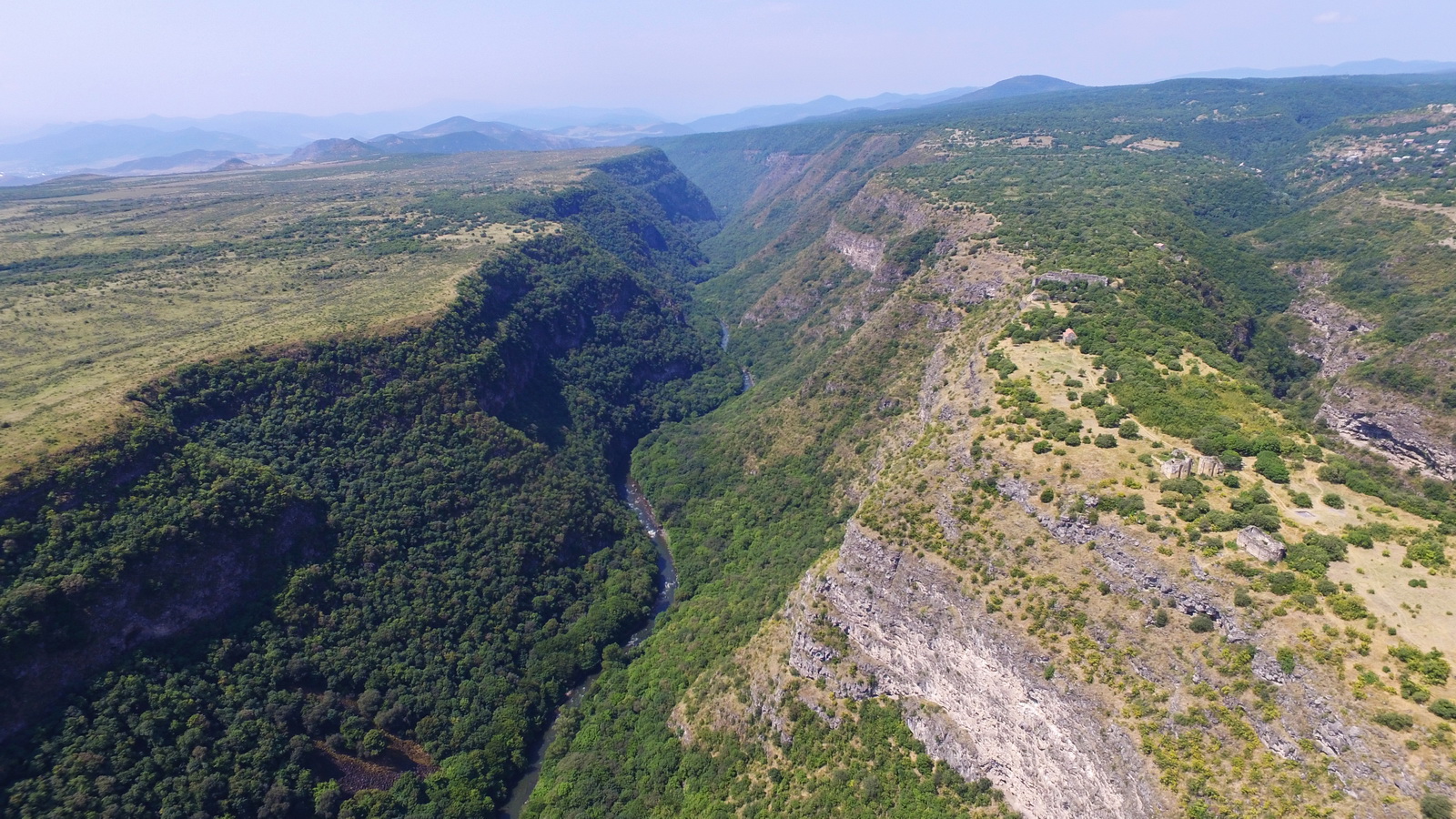
ქართული: ალგეთის ეროვნული პარკი — ეროვნული პარკი საქართველოში. მდებარეობს ისტორიულ ქვემო ქართლში, თეთრიწყაროს მუნიციპალიტეტში, ქალაქ თბილისიდან 60 კმ-ის დაშორებით. მოქცეულია მდინარე ალგეთის ხეობაში და მოიცავს თრიალეთის ქედის აღმოსავლეთ ნაწილის სამხრეთ ფერდობებს და ზღვის დონიდან 1100-1950 მ სიმაღლეზე მდებარეობს. უმაღლესი წერტილია კლდეკარი (2000 მ). English: Algeti National Park is a protected area in Georgia, in the southeast of the country. It lies in the region of Kvemo Kartli, within the Municipality of Tetritsqaro, some 60 km southwest of the nation’s capital, Tbilisi. |
Date | |
Source | Own work |
Author | Paata vardanashvili |
Camera location | 41° 30′ 21.36″ N, 44° 30′ 36.23″ E | View this and other nearby images on: OpenStreetMap | 41.505933; 44.510063 |
---|
Assessment
[edit]
This image won the 6th prize in the national contest of Georgia in Wiki Loves Earth 2018 Other languages:
العربية ∙ বাংলা ∙ Deutsch ∙ Ελληνικά ∙ English ∙ español ∙ français ∙ hrvatski ∙ Bahasa Indonesia ∙ italiano ∙ македонски ∙ Nederlands ∙ português ∙ română ∙ русский ∙ slovenščina ∙ svenska ∙ українська ∙ +/− |
This image was uploaded as part of Wiki Loves Earth 2018.
aragonés | العربية | asturianu | azərbaycanca | беларуская (тарашкевіца) | български | বাংলা | brezhoneg | català | čeština | Cymraeg | Deutsch | Ελληνικά | English | español | eesti | euskara | فارسی | français | galego | עברית | hrvatski | հայերեն | Bahasa Indonesia | italiano | 日本語 | ქართული | 한국어 | latviešu | македонски | മലയാളം | मराठी | Bahasa Melayu | norsk bokmål | नेपाली | Nederlands | norsk | polski | português | português do Brasil | русский | sicilianu | shqip | slovenščina | српски / srpski | svenska | ไทย | Türkçe | українська | اردو | 中文 | 中文(台灣) | +/− |
Licensing
[edit]- You are free:
- to share – to copy, distribute and transmit the work
- to remix – to adapt the work
- Under the following conditions:
- attribution – You must give appropriate credit, provide a link to the license, and indicate if changes were made. You may do so in any reasonable manner, but not in any way that suggests the licensor endorses you or your use.
- share alike – If you remix, transform, or build upon the material, you must distribute your contributions under the same or compatible license as the original.
File history
Click on a date/time to view the file as it appeared at that time.
Date/Time | Thumbnail | Dimensions | User | Comment | |
---|---|---|---|---|---|
current | 15:04, 26 June 2018 | 1,600 × 900 (726 KB) | Paata vardanashvili (talk | contribs) | User created page with UploadWizard |
You cannot overwrite this file.
File usage on Commons
The following 4 pages use this file:
File usage on other wikis
The following other wikis use this file:
- Usage on fr.wikipedia.org
- Usage on ka.wikipedia.org
- Usage on lt.wikipedia.org
- Usage on nl.wikipedia.org
Metadata
This file contains additional information such as Exif metadata which may have been added by the digital camera, scanner, or software program used to create or digitize it. If the file has been modified from its original state, some details such as the timestamp may not fully reflect those of the original file. The timestamp is only as accurate as the clock in the camera, and it may be completely wrong.
Image title |
|
---|---|
Camera manufacturer | DJI |
Camera model | FC300S |
Exposure time | 1,473/1,000,000 sec (0.001473) |
F-number | f/2.8 |
ISO speed rating | 100 |
Date and time of data generation | 03:51, 4 August 2017 |
Lens focal length | 3.61 mm |
Latitude | 41° 30′ 21.36″ N |
Longitude | 44° 30′ 36.23″ E |
Altitude | 934.215 meters above sea level |
Orientation | Normal |
Horizontal resolution | 72 dpi |
Vertical resolution | 72 dpi |
Software used | ACDSee Professional 2018 |
File change date and time | 13:22, 25 June 2018 |
Y and C positioning | Centered |
Exposure Program | Normal program |
Exif version | 2.3 |
Date and time of digitizing | 03:51, 4 August 2017 |
Meaning of each component |
|
Image compression mode | 3.1776453333333 |
APEX aperture | 2 |
APEX exposure bias | 1.34375 |
Maximum land aperture | 2 APEX (f/2) |
Subject distance | 0 meters |
Metering mode | Spot |
Light source | Unknown |
Flash | Flash did not fire, No flash function |
DateTime subseconds | 942 |
Supported Flashpix version | 0.1 |
Color space | sRGB |
File source | Digital still camera |
Scene type | 0 |
Custom image processing | Normal process |
Exposure mode | Auto exposure |
White balance | Auto white balance |
Focal length in 35 mm film | 20 mm |
Scene capture type | Standard |
Scene control | None |
Contrast | Normal |
Saturation | Normal |
Sharpness | Normal |
Subject distance range | Unknown |
GPS tag version | 0.0.2.3 |
Date metadata was last modified | 16:18, 7 August 2017 |
Unique ID of original document | 64AA2DC7432A61749897BA3E4C22BBDA |
Structured data
Items portrayed in this file
depicts
41°30'21.359"N, 44°30'36.227"E
4 August 2017
image/jpeg
- Files with coordinates missing SDC location of creation
- Images from Wiki Loves Earth 2018
- Images from Wiki Loves Earth 2018 in Georgia
- Images from Wiki Loves Earth missing SDC depicts
- Images from Wiki Loves Earth missing SDC location of creation
- CC-BY-SA-4.0
- Self-published work
- Uploaded via Campaign:wle-ge
- Georgia photographs taken on 2017-08-04