File:View from Flash Jack's Hill - panoramio.jpg
Jump to navigation
Jump to search

Size of this preview: 800 × 154 pixels. Other resolutions: 320 × 62 pixels | 640 × 123 pixels | 1,024 × 197 pixels | 1,280 × 246 pixels | 9,158 × 1,763 pixels.
Original file (9,158 × 1,763 pixels, file size: 6.67 MB, MIME type: image/jpeg)
Captions
Captions
Add a one-line explanation of what this file represents
Summary
[edit]
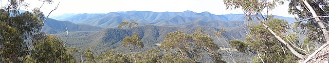
| Description | View from Flash Jack's Hill | ||
| Date | 16 May 2010 (original upload date) | ||
| Source | https://web.archive.org/web/20161119180849/http://www.panoramio.com/photo/35574721 | ||
| Author | dnatheist | ||
| Permission (Reusing this file) |
This file is licensed under the Creative Commons Attribution 3.0 Unported license. Attribution: dnatheist
|
||
| Other versions | |||
| Tags (from Panoramio photo page) | Deua, Australia, Canoolie, Duea, NSW, Panorama, View |
| Camera location | | View this and other nearby images on: OpenStreetMap |
|---|
File history
Click on a date/time to view the file as it appeared at that time.
| Date/Time | Thumbnail | Dimensions | User | Comment | |
|---|---|---|---|---|---|
| current | 19:14, 10 December 2016 | 9,158 × 1,763 (6.67 MB) | Panoramio upload bot (talk | contribs) | == {{int:filedesc}} == {{Information |description=View from Flash Jack's Hill |date={{Original upload date|2010-05-16}} |source=http://www.panoramio.com/photo/35574721 |author=[http://www.panoramio.com/user/351260?with_photo_id=35574721 dnatheist] |per... |
You cannot overwrite this file.
File usage on Commons
The following page uses this file: