File:View across the river - geograph.org.uk - 1285169.jpg
Jump to navigation
Jump to search

Size of this preview: 450 × 600 pixels. Other resolutions: 180 × 240 pixels | 480 × 640 pixels.
Original file (480 × 640 pixels, file size: 112 KB, MIME type: image/jpeg)
Captions
Captions
Add a one-line explanation of what this file represents
Summary
[edit]
| Description |
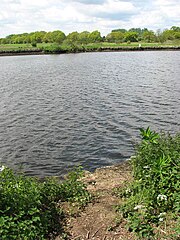
English: View across the river. This circular walk on the Wherrymans Way starts and ends at St Mary's church > https://www.geograph.org.uk/photo/1280845. Leading in northerly direction past the church the path descends to the Surlingham Landspring Main Sluice > https://www.geograph.org.uk/photo/1285128. A boardwalk has been built along sections of path > 1285135 which here runs parallel with a drain > 1285139 which empties into the River Yare > 1285145. The path follows the Wherrymans Way which here runs parallel with the river > 1285201 in northerly direction, leading past Surlingham Church Marsh Nature Reserve > 1285247. Shortly before reaching the Ferry Inn, the circular walk turns in easterly direction while a permissive path splits off here, continuing northwards along the river 1285274. The path follows a drain which separates in from reed beds > 1285309 but soon ascends towards higher, drier ground and pastureland > 1285327. Here it skirts a stockfence surrounding a cattle pasture, turning in southerly direction, passing the Norwich & District Parabellum and Fullbore Club > 1285342 - 1285363 before reaching the peaceful ruins of St Saviour's church > 1280780. Turning southwesterly, the walk skirts a small woodland and passes Surlingham Landspring Secondary Sluice > 1280723 and continuing uphill passes an honesty stall where honey can be purchased in the passing > 1280719. The last section of path leads past St Mary's churchyard > 1280716 and the flint and brick cottage > 1280708 where it started.
The River Yare rises south of Dereham. It flows eastwards, skirting the southern edge of the city of Norwich. At Whitlingham it is joined by the River Wensum and just before reaching Reedham it is joined by the River Chet. Once past Reedham the river passes long stretches of marshland before it enters the tidal lake of Breydon Water where it is joined by the Rivers Bure and Waveney, and finally flows into the North Sea at Gorleston just south of Great Yarmouth. The Wherrymans Way is a 35-mile long distance footpath following the route of the Broads trading wherries between Norwich and Great Yarmouth. The route takes its name from the wherry - a large cargo-carrying barge whose black sails used to be a common sight on these waters. Ten circular village walks branch off this path along the way. |
| Date | |
| Source | From geograph.org.uk |
| Author | Evelyn Simak |
| Attribution (required by the license) | Evelyn Simak / View across the river / |
| Camera location | | View this and other nearby images on: OpenStreetMap |
|---|
_heading:292.00&language=en)
| Object location | | View this and other nearby images on: OpenStreetMap |
|---|
_heading:292.00&language=en)
Licensing
[edit]

|
This image was taken from the Geograph project collection. See this photograph's page on the Geograph website for the photographer's contact details. The copyright on this image is owned by Evelyn Simak and is licensed for reuse under the Creative Commons Attribution-ShareAlike 2.0 license.
|
This file is licensed under the Creative Commons Attribution-Share Alike 2.0 Generic license.
Attribution: Evelyn Simak
- You are free:
- to share – to copy, distribute and transmit the work
- to remix – to adapt the work
- Under the following conditions:
- attribution – You must give appropriate credit, provide a link to the license, and indicate if changes were made. You may do so in any reasonable manner, but not in any way that suggests the licensor endorses you or your use.
- share alike – If you remix, transform, or build upon the material, you must distribute your contributions under the same or compatible license as the original.
File history
Click on a date/time to view the file as it appeared at that time.
| Date/Time | Thumbnail | Dimensions | User | Comment | |
|---|---|---|---|---|---|
| current | 07:43, 27 February 2011 | | 480 × 640 (112 KB) | GeographBot (talk | contribs) | == {{int:filedesc}} == {{Information |description={{en|1=View across the river This circular walk on the Wherrymans Way starts and ends at St Mary's church > http://www.geograph.org.uk/photo/1280845. Leading in northerly direction past the church the pat |
You cannot overwrite this file.
File usage on Commons
There are no pages that use this file.